You are here: Home > Network List > CN - Canadian National Seismograph Network Stations List
> Station INK INUVIK, NT > Earthquake Result Viewer
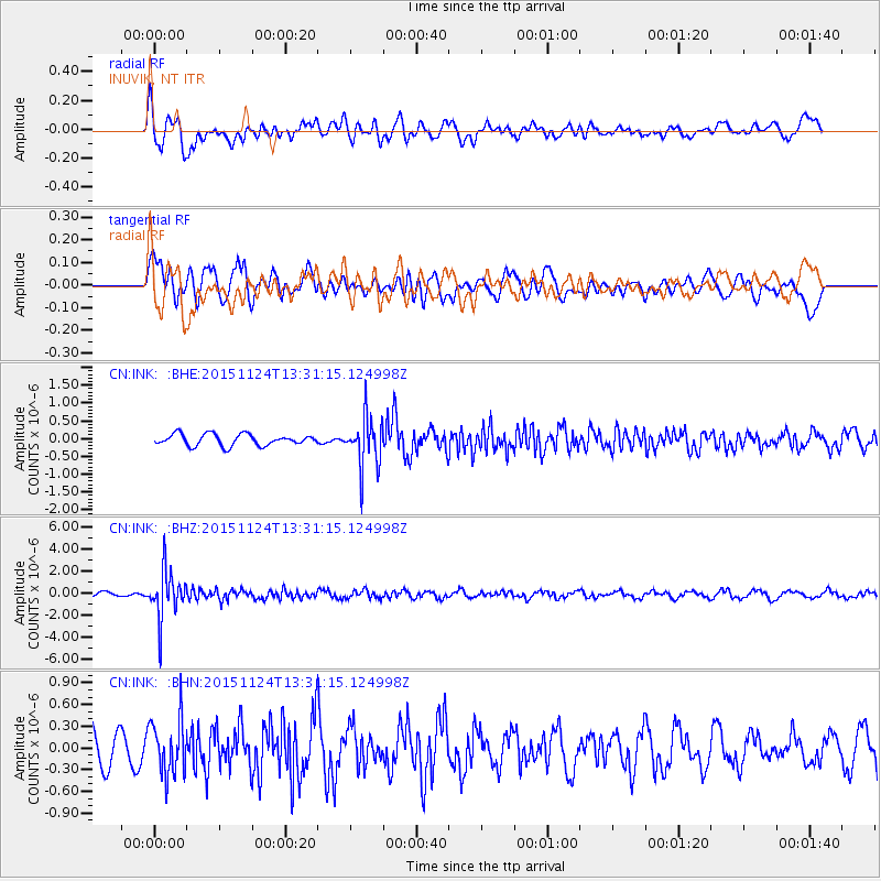
INK INUVIK, NT - Earthquake Result Viewer
*The percent match for this event was below the threshold and hence no stack was calculated.
| Earthquake location: |
Mariana Islands |
| Earthquake latitude/longitude: |
18.8/145.3 |
| Earthquake time(UTC): |
2015/11/24 (328) 13:21:36 GMT |
| Earthquake Depth: |
586 km |
| Earthquake Magnitude: |
5.9 MWB |
| Earthquake Catalog/Contributor: |
NEIC PDE/NEIC COMCAT |
|
| Network: |
CN Canadian National Seismograph Network |
| Station: |
INK INUVIK, NT |
| Lat/Lon: |
68.31 N/133.53 W |
| Elevation: |
44 m |
|
| Distance: |
69.4 deg |
| Az: |
23.101 deg |
| Baz: |
269.019 deg |
| Ray Param: |
$rayparam |
*The percent match for this event was below the threshold and hence was not used in the summary stack. |
|
| Radial Match: |
63.464886 % |
| Radial Bump: |
400 |
| Transverse Match: |
42.149315 % |
| Transverse Bump: |
400 |
| SOD ConfigId: |
7422571 |
| Insert Time: |
2019-04-21 11:08:13.385 +0000 |
| GWidth: |
2.5 |
| Max Bumps: |
400 |
| Tol: |
0.001 |
|
Signal To Noise
| Channel | StoN | STA | LTA |
| CN:INK: :BHZ:20151124T13:31:15.124998Z | 9.95086 | 2.126372E-6 | 2.1368726E-7 |
| CN:INK: :BHN:20151124T13:31:15.124998Z | 1.7160534 | 3.8116627E-7 | 2.2211795E-7 |
| CN:INK: :BHE:20151124T13:31:15.124998Z | 4.574871 | 7.3328334E-7 | 1.6028503E-7 |
| Arrivals |
| Ps | |
| PpPs | |
| PsPs/PpSs | |


