You are here: Home > Network List > CI - Caltech Regional Seismic Network Stations List
> Station PAS Pasadena, Pasadena, CA, USA > Earthquake Result Viewer
PAS Pasadena, Pasadena, CA, USA - Earthquake Result Viewer

| Earthquake location: |
Kodiak Island Region, Alaska |
| Earthquake latitude/longitude: |
57.4/-154.4 |
| Earthquake time(UTC): |
1999/12/06 (340) 23:22:55 GMT |
| Earthquake Depth: |
50 km |
| Earthquake Magnitude: |
5.6 MB, 5.5 ML, 5.4 ML |
| Earthquake Catalog/Contributor: |
WHDF/NEIC |
|
| Network: |
CI Caltech Regional Seismic Network |
| Station: |
PAS Pasadena, Pasadena, CA, USA |
| Lat/Lon: |
34.15 N/118.17 W |
| Elevation: |
314 m |
|
| Distance: |
33.7 deg |
| Az: |
117.895 deg |
| Baz: |
324.726 deg |
| Ray Param: |
0.07798624 |
| Estimated Moho Depth: |
46.25 km |
| Estimated Crust Vp/Vs: |
1.84 |
| Assumed Crust Vp: |
6.1 km/s |
| Estimated Crust Vs: |
3.315 km/s |
| Estimated Crust Poisson's Ratio: |
0.29 |
|
| Radial Match: |
90.05009 % |
| Radial Bump: |
400 |
| Transverse Match: |
79.90148 % |
| Transverse Bump: |
308 |
| SOD ConfigId: |
3770 |
| Insert Time: |
2010-02-25 23:57:33.548 +0000 |
| GWidth: |
2.5 |
| Max Bumps: |
400 |
| Tol: |
0.001 |
|
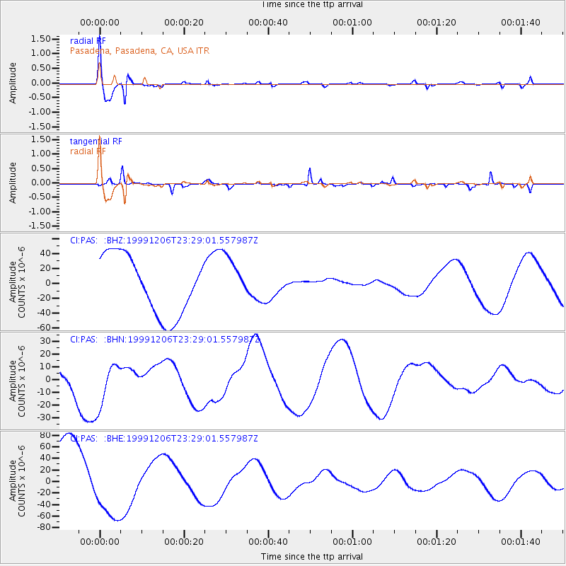
Signal To Noise
| Channel | StoN | STA | LTA |
| CI:PAS: :BHN:19991206T23:29:01.557987Z | 0.7705979 | 1.6614238E-5 | 2.1560192E-5 |
| CI:PAS: :BHE:19991206T23:29:01.557987Z | 1.0928133 | 5.8547008E-5 | 5.357458E-5 |
| CI:PAS: :BHZ:19991206T23:29:01.557987Z | 0.7739029 | 3.0462188E-5 | 3.936177E-5 |
| Arrivals |
| Ps | 6.8 SECOND |
| PpPs | 20 SECOND |
| PsPs/PpSs | 27 SECOND |


