You are here: Home > Network List > IU - Global Seismograph Network (GSN - IRIS/USGS) Stations List
> Station KBL Kabul, Afghanistan > Earthquake Result Viewer
KBL Kabul, Afghanistan - Earthquake Result Viewer
| Earthquake location: |
Mariana Islands |
| Earthquake latitude/longitude: |
18.8/145.3 |
| Earthquake time(UTC): |
2015/11/24 (328) 13:21:36 GMT |
| Earthquake Depth: |
586 km |
| Earthquake Magnitude: |
5.9 MWB |
| Earthquake Catalog/Contributor: |
NEIC PDE/NEIC COMCAT |
|
| Network: |
IU Global Seismograph Network (GSN - IRIS/USGS) |
| Station: |
KBL Kabul, Afghanistan |
| Lat/Lon: |
34.54 N/69.04 E |
| Elevation: |
1920 m |
|
| Distance: |
68.5 deg |
| Az: |
300.482 deg |
| Baz: |
81.527 deg |
| Ray Param: |
0.054181747 |
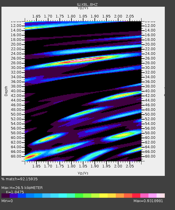
| Estimated Moho Depth: |
26.5 km |
| Estimated Crust Vp/Vs: |
1.85 |
| Assumed Crust Vp: |
6.641 km/s |
| Estimated Crust Vs: |
3.594 km/s |
| Estimated Crust Poisson's Ratio: |
0.29 |
|
| Radial Match: |
92.15935 % |
| Radial Bump: |
400 |
| Transverse Match: |
86.3674 % |
| Transverse Bump: |
400 |
| SOD ConfigId: |
7422571 |
| Insert Time: |
2019-04-21 11:09:01.313 +0000 |
| GWidth: |
2.5 |
| Max Bumps: |
400 |
| Tol: |
0.001 |
|
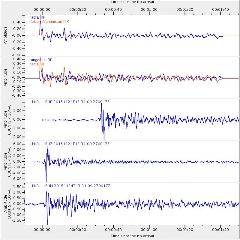
Signal To Noise
| Channel | StoN | STA | LTA |
| IU:KBL: :BHZ:20151124T13:31:09.270017Z | 51.629887 | 2.2206355E-6 | 4.3010658E-8 |
| IU:KBL: :BHN:20151124T13:31:09.270017Z | 19.235132 | 5.6499465E-7 | 2.9373055E-8 |
| IU:KBL: :BHE:20151124T13:31:09.270017Z | 26.0402 | 7.999107E-7 | 3.07183E-8 |
| Arrivals |
| Ps | 3.5 SECOND |
| PpPs | 11 SECOND |
| PsPs/PpSs | 14 SECOND |


