You are here: Home > Network List > TA - USArray Transportable Network (new EarthScope stations) Stations List
> Station M31M Drury Creek, Yukon, CA > Earthquake Result Viewer
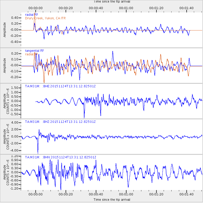
M31M Drury Creek, Yukon, CA - Earthquake Result Viewer
*The percent match for this event was below the threshold and hence no stack was calculated.
| Earthquake location: |
Mariana Islands |
| Earthquake latitude/longitude: |
18.8/145.3 |
| Earthquake time(UTC): |
2015/11/24 (328) 13:21:36 GMT |
| Earthquake Depth: |
586 km |
| Earthquake Magnitude: |
5.9 MWB |
| Earthquake Catalog/Contributor: |
NEIC PDE/NEIC COMCAT |
|
| Network: |
TA USArray Transportable Network (new EarthScope stations) |
| Station: |
M31M Drury Creek, Yukon, CA |
| Lat/Lon: |
62.20 N/134.39 W |
| Elevation: |
639 m |
|
| Distance: |
69.1 deg |
| Az: |
29.656 deg |
| Baz: |
270.557 deg |
| Ray Param: |
$rayparam |
*The percent match for this event was below the threshold and hence was not used in the summary stack. |
|
| Radial Match: |
58.55053 % |
| Radial Bump: |
400 |
| Transverse Match: |
55.460594 % |
| Transverse Bump: |
400 |
| SOD ConfigId: |
7422571 |
| Insert Time: |
2019-04-21 11:11:51.236 +0000 |
| GWidth: |
2.5 |
| Max Bumps: |
400 |
| Tol: |
0.001 |
|
Signal To Noise
| Channel | StoN | STA | LTA |
| TA:M31M: :BHZ:20151124T13:31:12.82501Z | 3.6191669 | 1.2301396E-6 | 3.398958E-7 |
| TA:M31M: :BHN:20151124T13:31:12.82501Z | 1.9502943 | 3.9478937E-7 | 2.0242553E-7 |
| TA:M31M: :BHE:20151124T13:31:12.82501Z | 2.6048055 | 4.9057434E-7 | 1.8833435E-7 |
| Arrivals |
| Ps | |
| PpPs | |
| PsPs/PpSs | |


