You are here: Home > Network List > CI - Caltech Regional Seismic Network Stations List
> Station PAS Pasadena, Pasadena, CA, USA > Earthquake Result Viewer
PAS Pasadena, Pasadena, CA, USA - Earthquake Result Viewer

| Earthquake location: |
Near Islands, Aleutian Islands |
| Earthquake latitude/longitude: |
53.4/171.4 |
| Earthquake time(UTC): |
1999/11/13 (317) 19:31:12 GMT |
| Earthquake Depth: |
33 km |
| Earthquake Magnitude: |
5.5 MB, 5.5 MS, 5.9 MW, 5.8 MW |
| Earthquake Catalog/Contributor: |
WHDF/NEIC |
|
| Network: |
CI Caltech Regional Seismic Network |
| Station: |
PAS Pasadena, Pasadena, CA, USA |
| Lat/Lon: |
34.15 N/118.17 W |
| Elevation: |
314 m |
|
| Distance: |
52.1 deg |
| Az: |
81.82 deg |
| Baz: |
314.323 deg |
| Ray Param: |
0.06689986 |
| Estimated Moho Depth: |
28.75 km |
| Estimated Crust Vp/Vs: |
1.69 |
| Assumed Crust Vp: |
6.1 km/s |
| Estimated Crust Vs: |
3.62 km/s |
| Estimated Crust Poisson's Ratio: |
0.23 |
|
| Radial Match: |
85.70442 % |
| Radial Bump: |
400 |
| Transverse Match: |
72.63872 % |
| Transverse Bump: |
400 |
| SOD ConfigId: |
3770 |
| Insert Time: |
2010-02-25 23:57:38.100 +0000 |
| GWidth: |
2.5 |
| Max Bumps: |
400 |
| Tol: |
0.001 |
|
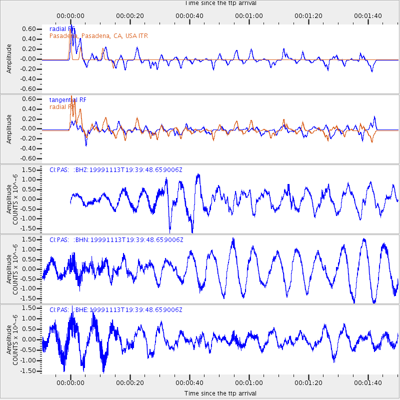
Signal To Noise
| Channel | StoN | STA | LTA |
| CI:PAS: :BHN:19991113T19:39:48.659006Z | 1.5820824 | 4.2719174E-7 | 2.7001863E-7 |
| CI:PAS: :BHE:19991113T19:39:48.659006Z | 2.085655 | 8.065317E-7 | 3.8670427E-7 |
| CI:PAS: :BHZ:19991113T19:39:48.659006Z | 2.3096476 | 6.7974594E-7 | 2.9430723E-7 |
| Arrivals |
| Ps | 3.4 SECOND |
| PpPs | 12 SECOND |
| PsPs/PpSs | 15 SECOND |


