You are here: Home > Network List > G - GEOSCOPE Stations List
> Station INU Inuyama, Japan > Earthquake Result Viewer
INU Inuyama, Japan - Earthquake Result Viewer
| Earthquake location: |
Timor Region |
| Earthquake latitude/longitude: |
-9.9/125.1 |
| Earthquake time(UTC): |
2015/06/15 (166) 17:40:57 GMT |
| Earthquake Depth: |
66 km |
| Earthquake Magnitude: |
5.8 MO |
| Earthquake Catalog/Contributor: |
NEIC PDE/NEIC ALERT |
|
| Network: |
G GEOSCOPE |
| Station: |
INU Inuyama, Japan |
| Lat/Lon: |
35.35 N/137.03 E |
| Elevation: |
132 m |
|
| Distance: |
46.4 deg |
| Az: |
13.496 deg |
| Baz: |
196.339 deg |
| Ray Param: |
0.07049823 |
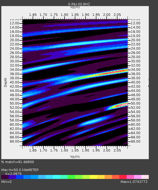
| Estimated Moho Depth: |
50.0 km |
| Estimated Crust Vp/Vs: |
2.10 |
| Assumed Crust Vp: |
6.461 km/s |
| Estimated Crust Vs: |
3.081 km/s |
| Estimated Crust Poisson's Ratio: |
0.35 |
|
| Radial Match: |
91.66988 % |
| Radial Bump: |
381 |
| Transverse Match: |
67.749535 % |
| Transverse Bump: |
400 |
| SOD ConfigId: |
976571 |
| Insert Time: |
2015-06-29 18:08:56.430 +0000 |
| GWidth: |
2.5 |
| Max Bumps: |
400 |
| Tol: |
0.001 |
|
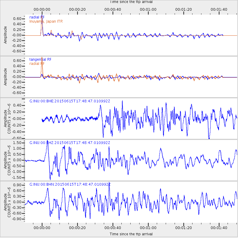
Signal To Noise
| Channel | StoN | STA | LTA |
| G:INU:00:BHZ:20150615T17:48:47.010992Z | 14.535577 | 8.1239534E-7 | 5.5890133E-8 |
| G:INU:00:BHN:20150615T17:48:47.010992Z | 5.9741035 | 3.7080355E-7 | 6.206849E-8 |
| G:INU:00:BHE:20150615T17:48:47.010992Z | 4.076937 | 2.159198E-7 | 5.296128E-8 |
| Arrivals |
| Ps | 9.0 SECOND |
| PpPs | 23 SECOND |
| PsPs/PpSs | 32 SECOND |


