You are here: Home > Network List > TA - USArray Transportable Network (new EarthScope stations) Stations List
> Station MSTX Muleshoe, TX, USA > Earthquake Result Viewer
MSTX Muleshoe, TX, USA - Earthquake Result Viewer
*The percent match for this event was below the threshold and hence no stack was calculated.
| Earthquake location: |
North Of Ascension Island |
| Earthquake latitude/longitude: |
-0.1/-17.8 |
| Earthquake time(UTC): |
2015/11/24 (328) 20:45:02 GMT |
| Earthquake Depth: |
10 km |
| Earthquake Magnitude: |
5.5 mwb |
| Earthquake Catalog/Contributor: |
NEIC PDE/us |
|
| Network: |
TA USArray Transportable Network (new EarthScope stations) |
| Station: |
MSTX Muleshoe, TX, USA |
| Lat/Lon: |
33.97 N/102.77 W |
| Elevation: |
1167 m |
|
| Distance: |
85.8 deg |
| Az: |
303.901 deg |
| Baz: |
92.901 deg |
| Ray Param: |
$rayparam |
*The percent match for this event was below the threshold and hence was not used in the summary stack. |
|
| Radial Match: |
77.567085 % |
| Radial Bump: |
400 |
| Transverse Match: |
55.641895 % |
| Transverse Bump: |
400 |
| SOD ConfigId: |
7422571 |
| Insert Time: |
2019-04-21 11:20:38.918 +0000 |
| GWidth: |
2.5 |
| Max Bumps: |
400 |
| Tol: |
0.001 |
|
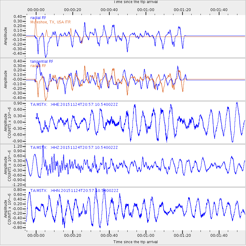
Signal To Noise
| Channel | StoN | STA | LTA |
| TA:MSTX: :HHZ:20151124T20:57:10.540022Z | 3.2358484 | 5.8884615E-7 | 1.8197582E-7 |
| TA:MSTX: :HHN:20151124T20:57:10.540022Z | 0.6517858 | 1.7645986E-7 | 2.707329E-7 |
| TA:MSTX: :HHE:20151124T20:57:10.540022Z | 1.8173684 | 3.840472E-7 | 2.1132053E-7 |
| Arrivals |
| Ps | |
| PpPs | |
| PsPs/PpSs | |


