You are here: Home > Network List > UU - University of Utah Regional Network Stations List
> Station CCUT Cedar City, UT, USA > Earthquake Result Viewer
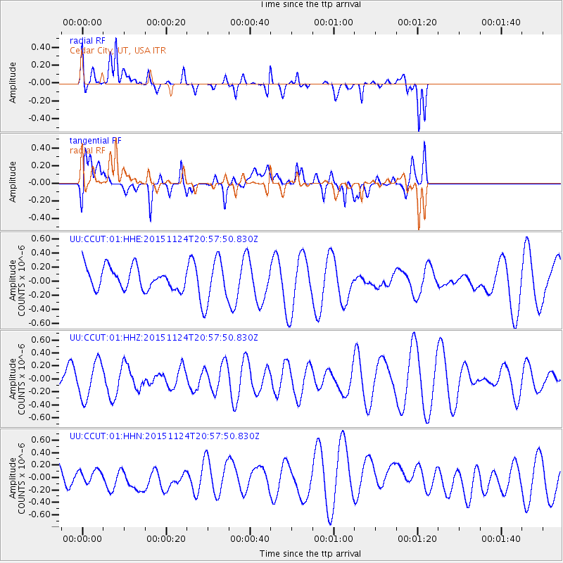
CCUT Cedar City, UT, USA - Earthquake Result Viewer
*The percent match for this event was below the threshold and hence no stack was calculated.
| Earthquake location: |
North Of Ascension Island |
| Earthquake latitude/longitude: |
-0.1/-17.8 |
| Earthquake time(UTC): |
2015/11/24 (328) 20:45:02 GMT |
| Earthquake Depth: |
10 km |
| Earthquake Magnitude: |
5.5 mwb |
| Earthquake Catalog/Contributor: |
NEIC PDE/us |
|
| Network: |
UU University of Utah Regional Network |
| Station: |
CCUT Cedar City, UT, USA |
| Lat/Lon: |
37.55 N/113.36 W |
| Elevation: |
2127 m |
|
| Distance: |
94.5 deg |
| Az: |
307.488 deg |
| Baz: |
86.716 deg |
| Ray Param: |
$rayparam |
*The percent match for this event was below the threshold and hence was not used in the summary stack. |
|
| Radial Match: |
64.504524 % |
| Radial Bump: |
364 |
| Transverse Match: |
43.39167 % |
| Transverse Bump: |
400 |
| SOD ConfigId: |
7422571 |
| Insert Time: |
2019-04-21 11:21:13.043 +0000 |
| GWidth: |
2.5 |
| Max Bumps: |
400 |
| Tol: |
0.001 |
|
Signal To Noise
| Channel | StoN | STA | LTA |
| UU:CCUT:01:HHZ:20151124T20:57:50.830Z | 1.5706717 | 2.883991E-7 | 1.8361514E-7 |
| UU:CCUT:01:HHN:20151124T20:57:50.830Z | 0.6290644 | 1.0008515E-7 | 1.591016E-7 |
| UU:CCUT:01:HHE:20151124T20:57:50.830Z | 2.0410664 | 3.164274E-7 | 1.5503043E-7 |
| Arrivals |
| Ps | |
| PpPs | |
| PsPs/PpSs | |


