You are here: Home > Network List > 7A - Mid-Atlantic Geophysical Integrative Collaboration Stations List
> Station BARB Louisa, Virginia USA > Earthquake Result Viewer
BARB Louisa, Virginia USA - Earthquake Result Viewer
| Earthquake location: |
Peru-Brazil Border Region |
| Earthquake latitude/longitude: |
-10.6/-71.0 |
| Earthquake time(UTC): |
2015/11/24 (328) 22:45:38 GMT |
| Earthquake Depth: |
602 km |
| Earthquake Magnitude: |
7.5 MWW, 6.9 MI |
| Earthquake Catalog/Contributor: |
NEIC PDE/NEIC COMCAT |
|
| Network: |
7A Mid-Atlantic Geophysical Integrative Collaboration |
| Station: |
BARB Louisa, Virginia USA |
| Lat/Lon: |
37.99 N/78.09 W |
| Elevation: |
84 m |
|
| Distance: |
48.8 deg |
| Az: |
352.519 deg |
| Baz: |
170.676 deg |
| Ray Param: |
0.06625993 |
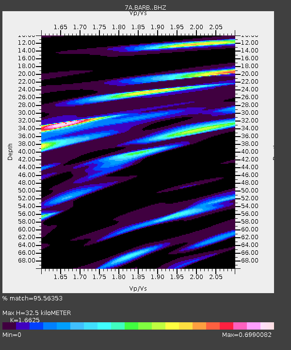
| Estimated Moho Depth: |
32.5 km |
| Estimated Crust Vp/Vs: |
1.66 |
| Assumed Crust Vp: |
6.419 km/s |
| Estimated Crust Vs: |
3.861 km/s |
| Estimated Crust Poisson's Ratio: |
0.22 |
|
| Radial Match: |
95.56353 % |
| Radial Bump: |
236 |
| Transverse Match: |
82.38736 % |
| Transverse Bump: |
400 |
| SOD ConfigId: |
7422571 |
| Insert Time: |
2019-04-21 11:22:48.309 +0000 |
| GWidth: |
2.5 |
| Max Bumps: |
400 |
| Tol: |
0.001 |
|

Signal To Noise
| Channel | StoN | STA | LTA |
| 7A:BARB: :BHZ:20151124T22:52:59.114993Z | 43.471737 | 1.13203305E-5 | 2.6040667E-7 |
| 7A:BARB: :BHN:20151124T22:52:59.114993Z | 29.787025 | 7.2388934E-6 | 2.430217E-7 |
| 7A:BARB: :BHE:20151124T22:52:59.114993Z | 10.307964 | 2.2391594E-6 | 2.1722614E-7 |
| Arrivals |
| Ps | 3.6 SECOND |
| PpPs | 13 SECOND |
| PsPs/PpSs | 16 SECOND |


