You are here: Home > Network List > 7A - Mid-Atlantic Geophysical Integrative Collaboration Stations List
> Station PAUL Paulding, Ohio USA > Earthquake Result Viewer
PAUL Paulding, Ohio USA - Earthquake Result Viewer
| Earthquake location: |
Peru-Brazil Border Region |
| Earthquake latitude/longitude: |
-10.6/-71.0 |
| Earthquake time(UTC): |
2015/11/24 (328) 22:45:38 GMT |
| Earthquake Depth: |
602 km |
| Earthquake Magnitude: |
7.5 MWW, 6.9 MI |
| Earthquake Catalog/Contributor: |
NEIC PDE/NEIC COMCAT |
|
| Network: |
7A Mid-Atlantic Geophysical Integrative Collaboration |
| Station: |
PAUL Paulding, Ohio USA |
| Lat/Lon: |
41.14 N/84.55 W |
| Elevation: |
0.0 m |
|
| Distance: |
53.0 deg |
| Az: |
347.161 deg |
| Baz: |
163.187 deg |
| Ray Param: |
0.063700736 |
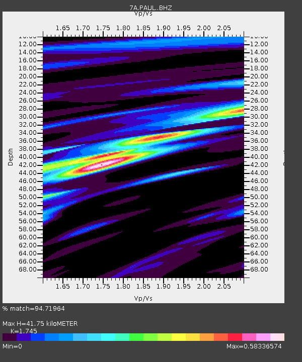
| Estimated Moho Depth: |
41.75 km |
| Estimated Crust Vp/Vs: |
1.75 |
| Assumed Crust Vp: |
6.498 km/s |
| Estimated Crust Vs: |
3.724 km/s |
| Estimated Crust Poisson's Ratio: |
0.26 |
|
| Radial Match: |
94.71964 % |
| Radial Bump: |
400 |
| Transverse Match: |
88.750824 % |
| Transverse Bump: |
400 |
| SOD ConfigId: |
7422571 |
| Insert Time: |
2019-04-21 11:23:08.185 +0000 |
| GWidth: |
2.5 |
| Max Bumps: |
400 |
| Tol: |
0.001 |
|

Signal To Noise
| Channel | StoN | STA | LTA |
| 7A:PAUL: :BHZ:20151124T22:53:29.315005Z | 19.90115 | 2.2958464E-5 | 1.1536249E-6 |
| 7A:PAUL: :BHN:20151124T22:53:29.315005Z | 11.237663 | 7.747931E-6 | 6.8946105E-7 |
| 7A:PAUL: :BHE:20151124T22:53:29.315005Z | 6.1297865 | 3.8115863E-6 | 6.218139E-7 |
| Arrivals |
| Ps | 5.0 SECOND |
| PpPs | 17 SECOND |
| PsPs/PpSs | 22 SECOND |


