You are here: Home > Network List > AV - Alaska Volcano Observatory Stations List
> Station SPCR Ckakachatna River, Mount Spurr, Alaska > Earthquake Result Viewer
SPCR Ckakachatna River, Mount Spurr, Alaska - Earthquake Result Viewer

| Earthquake location: |
Peru-Brazil Border Region |
| Earthquake latitude/longitude: |
-10.6/-71.0 |
| Earthquake time(UTC): |
2015/11/24 (328) 22:45:38 GMT |
| Earthquake Depth: |
602 km |
| Earthquake Magnitude: |
7.5 MWW, 6.9 MI |
| Earthquake Catalog/Contributor: |
NEIC PDE/NEIC COMCAT |
|
| Network: |
AV Alaska Volcano Observatory |
| Station: |
SPCR Ckakachatna River, Mount Spurr, Alaska |
| Lat/Lon: |
61.20 N/152.21 W |
| Elevation: |
984 m |
|
| Distance: |
95.0 deg |
| Az: |
331.287 deg |
| Baz: |
102.719 deg |
| Ray Param: |
0.04026984 |
| Estimated Moho Depth: |
19.75 km |
| Estimated Crust Vp/Vs: |
1.62 |
| Assumed Crust Vp: |
6.566 km/s |
| Estimated Crust Vs: |
4.066 km/s |
| Estimated Crust Poisson's Ratio: |
0.19 |
|
| Radial Match: |
83.25844 % |
| Radial Bump: |
400 |
| Transverse Match: |
70.66118 % |
| Transverse Bump: |
400 |
| SOD ConfigId: |
7422571 |
| Insert Time: |
2019-04-21 11:24:55.909 +0000 |
| GWidth: |
2.5 |
| Max Bumps: |
400 |
| Tol: |
0.001 |
|
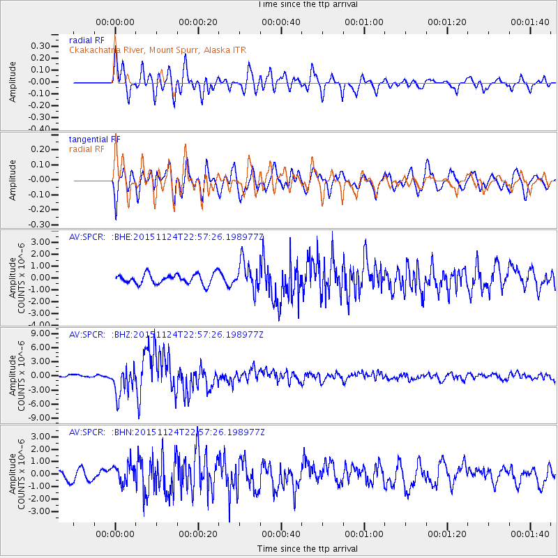
Signal To Noise
| Channel | StoN | STA | LTA |
| AV:SPCR: :BHZ:20151124T22:57:26.198977Z | 11.794925 | 3.0503697E-6 | 2.5861715E-7 |
| AV:SPCR: :BHN:20151124T22:57:26.198977Z | 2.3676493 | 7.686122E-7 | 3.2463095E-7 |
| AV:SPCR: :BHE:20151124T22:57:26.198977Z | 2.90607 | 1.2273082E-6 | 4.2232574E-7 |
| Arrivals |
| Ps | 1.9 SECOND |
| PpPs | 7.7 SECOND |
| PsPs/PpSs | 9.6 SECOND |


