You are here: Home > Network List > C1 - Red Sismologica Nacional Stations List
> Station LL04 Puerto Octay > Earthquake Result Viewer
LL04 Puerto Octay - Earthquake Result Viewer
| Earthquake location: |
Peru-Brazil Border Region |
| Earthquake latitude/longitude: |
-10.6/-71.0 |
| Earthquake time(UTC): |
2015/11/24 (328) 22:45:38 GMT |
| Earthquake Depth: |
602 km |
| Earthquake Magnitude: |
7.5 MWW, 6.9 MI |
| Earthquake Catalog/Contributor: |
NEIC PDE/NEIC COMCAT |
|
| Network: |
C1 Red Sismologica Nacional |
| Station: |
LL04 Puerto Octay |
| Lat/Lon: |
40.91 S/72.41 W |
| Elevation: |
247 m |
|
| Distance: |
30.2 deg |
| Az: |
182.172 deg |
| Baz: |
2.818 deg |
| Ray Param: |
0.07684294 |
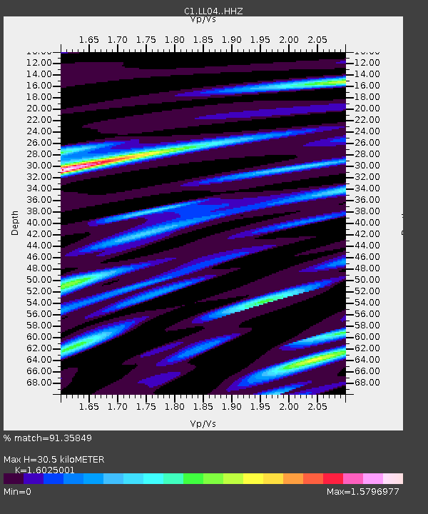
| Estimated Moho Depth: |
30.5 km |
| Estimated Crust Vp/Vs: |
1.60 |
| Assumed Crust Vp: |
6.522 km/s |
| Estimated Crust Vs: |
4.07 km/s |
| Estimated Crust Poisson's Ratio: |
0.18 |
|
| Radial Match: |
91.35849 % |
| Radial Bump: |
339 |
| Transverse Match: |
80.615364 % |
| Transverse Bump: |
400 |
| SOD ConfigId: |
7422571 |
| Insert Time: |
2019-04-21 11:25:27.062 +0000 |
| GWidth: |
2.5 |
| Max Bumps: |
400 |
| Tol: |
0.001 |
|

Signal To Noise
| Channel | StoN | STA | LTA |
| C1:LL04: :HHZ:20151124T22:50:32.239993Z | 39.04764 | 1.8707426E-5 | 4.790923E-7 |
| C1:LL04: :HHN:20151124T22:50:32.239993Z | 21.609367 | 1.36060435E-5 | 6.2963636E-7 |
| C1:LL04: :HHE:20151124T22:50:32.239993Z | 15.515612 | 4.4909084E-6 | 2.8944453E-7 |
| Arrivals |
| Ps | 3.1 SECOND |
| PpPs | 11 SECOND |
| PsPs/PpSs | 14 SECOND |


