You are here: Home > Network List > C1 - Red Sismologica Nacional Stations List
> Station LL02 Futaleufu > Earthquake Result Viewer
LL02 Futaleufu - Earthquake Result Viewer
| Earthquake location: |
Peru-Brazil Border Region |
| Earthquake latitude/longitude: |
-10.6/-71.0 |
| Earthquake time(UTC): |
2015/11/24 (328) 22:45:38 GMT |
| Earthquake Depth: |
602 km |
| Earthquake Magnitude: |
7.5 MWW, 6.9 MI |
| Earthquake Catalog/Contributor: |
NEIC PDE/NEIC COMCAT |
|
| Network: |
C1 Red Sismologica Nacional |
| Station: |
LL02 Futaleufu |
| Lat/Lon: |
43.19 S/71.85 W |
| Elevation: |
368 m |
|
| Distance: |
32.5 deg |
| Az: |
181.202 deg |
| Baz: |
1.616 deg |
| Ray Param: |
0.07569796 |
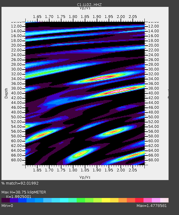
| Estimated Moho Depth: |
38.75 km |
| Estimated Crust Vp/Vs: |
1.99 |
| Assumed Crust Vp: |
6.597 km/s |
| Estimated Crust Vs: |
3.311 km/s |
| Estimated Crust Poisson's Ratio: |
0.33 |
|
| Radial Match: |
92.01992 % |
| Radial Bump: |
400 |
| Transverse Match: |
70.837746 % |
| Transverse Bump: |
400 |
| SOD ConfigId: |
7422571 |
| Insert Time: |
2019-04-21 11:25:27.838 +0000 |
| GWidth: |
2.5 |
| Max Bumps: |
400 |
| Tol: |
0.001 |
|

Signal To Noise
| Channel | StoN | STA | LTA |
| C1:LL02: :HHZ:20151124T22:50:51.38901Z | 23.083075 | 1.027282E-5 | 4.450369E-7 |
| C1:LL02: :HHN:20151124T22:50:51.38901Z | 21.951777 | 9.497109E-6 | 4.3263512E-7 |
| C1:LL02: :HHE:20151124T22:50:51.38901Z | 7.007227 | 2.7886263E-6 | 3.979643E-7 |
| Arrivals |
| Ps | 6.2 SECOND |
| PpPs | 16 SECOND |
| PsPs/PpSs | 23 SECOND |


