You are here: Home > Network List > CI - Caltech Regional Seismic Network Stations List
> Station CWC Cottonwood Creek, Lone Pine, CA, USA > Earthquake Result Viewer
CWC Cottonwood Creek, Lone Pine, CA, USA - Earthquake Result Viewer
| Earthquake location: |
Peru-Brazil Border Region |
| Earthquake latitude/longitude: |
-10.6/-71.0 |
| Earthquake time(UTC): |
2015/11/24 (328) 22:45:38 GMT |
| Earthquake Depth: |
602 km |
| Earthquake Magnitude: |
7.5 MWW, 6.9 MI |
| Earthquake Catalog/Contributor: |
NEIC PDE/NEIC COMCAT |
|
| Network: |
CI Caltech Regional Seismic Network |
| Station: |
CWC Cottonwood Creek, Lone Pine, CA, USA |
| Lat/Lon: |
36.44 N/118.08 W |
| Elevation: |
1595 m |
|
| Distance: |
64.4 deg |
| Az: |
319.08 deg |
| Baz: |
127.0 deg |
| Ray Param: |
0.056652576 |
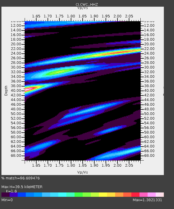
| Estimated Moho Depth: |
39.5 km |
| Estimated Crust Vp/Vs: |
1.60 |
| Assumed Crust Vp: |
6.291 km/s |
| Estimated Crust Vs: |
3.932 km/s |
| Estimated Crust Poisson's Ratio: |
0.18 |
|
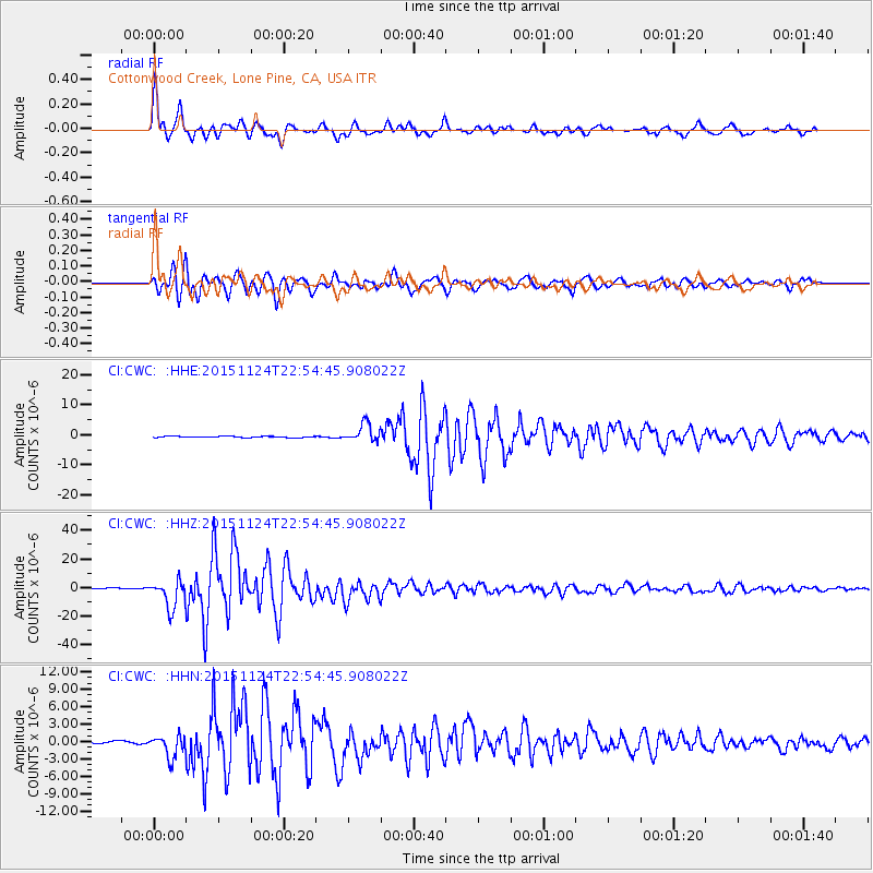
| Radial Match: |
96.689476 % |
| Radial Bump: |
400 |
| Transverse Match: |
95.203094 % |
| Transverse Bump: |
400 |
| SOD ConfigId: |
7422571 |
| Insert Time: |
2019-04-21 11:26:09.114 +0000 |
| GWidth: |
2.5 |
| Max Bumps: |
400 |
| Tol: |
0.001 |
|
Signal To Noise
| Channel | StoN | STA | LTA |
| CI:CWC: :HHZ:20151124T22:54:45.908022Z | 33.712116 | 9.790216E-6 | 2.9040643E-7 |
| CI:CWC: :HHN:20151124T22:54:45.908022Z | 8.848494 | 1.9462943E-6 | 2.199577E-7 |
| CI:CWC: :HHE:20151124T22:54:45.908022Z | 14.950122 | 2.9249245E-6 | 1.9564554E-7 |
| Arrivals |
| Ps | 3.9 SECOND |
| PpPs | 16 SECOND |
| PsPs/PpSs | 20 SECOND |


