You are here: Home > Network List > CI - Caltech Regional Seismic Network Stations List
> Station IKP In-Ko-Pah, Jacumba, CA, USA > Earthquake Result Viewer
IKP In-Ko-Pah, Jacumba, CA, USA - Earthquake Result Viewer
| Earthquake location: |
Peru-Brazil Border Region |
| Earthquake latitude/longitude: |
-10.6/-71.0 |
| Earthquake time(UTC): |
2015/11/24 (328) 22:45:38 GMT |
| Earthquake Depth: |
602 km |
| Earthquake Magnitude: |
7.5 MWW, 6.9 MI |
| Earthquake Catalog/Contributor: |
NEIC PDE/NEIC COMCAT |
|
| Network: |
CI Caltech Regional Seismic Network |
| Station: |
IKP In-Ko-Pah, Jacumba, CA, USA |
| Lat/Lon: |
32.65 N/116.11 W |
| Elevation: |
906 m |
|
| Distance: |
60.9 deg |
| Az: |
316.786 deg |
| Baz: |
127.058 deg |
| Ray Param: |
0.05886588 |
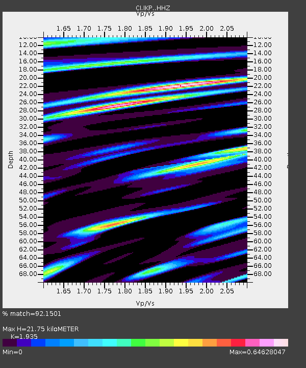
| Estimated Moho Depth: |
21.75 km |
| Estimated Crust Vp/Vs: |
1.93 |
| Assumed Crust Vp: |
6.264 km/s |
| Estimated Crust Vs: |
3.237 km/s |
| Estimated Crust Poisson's Ratio: |
0.32 |
|
| Radial Match: |
92.1501 % |
| Radial Bump: |
400 |
| Transverse Match: |
88.72503 % |
| Transverse Bump: |
400 |
| SOD ConfigId: |
7422571 |
| Insert Time: |
2019-04-21 11:26:19.729 +0000 |
| GWidth: |
2.5 |
| Max Bumps: |
400 |
| Tol: |
0.001 |
|

Signal To Noise
| Channel | StoN | STA | LTA |
| CI:IKP: :HHZ:20151124T22:54:23.028018Z | 22.25222 | 7.451501E-6 | 3.3486552E-7 |
| CI:IKP: :HHN:20151124T22:54:23.028018Z | 10.90412 | 1.7262605E-6 | 1.5831267E-7 |
| CI:IKP: :HHE:20151124T22:54:23.028018Z | 11.381009 | 2.7229512E-6 | 2.3925395E-7 |
| Arrivals |
| Ps | 3.4 SECOND |
| PpPs | 9.8 SECOND |
| PsPs/PpSs | 13 SECOND |


