You are here: Home > Network List > CI - Caltech Regional Seismic Network Stations List
> Station MPM Manuel Prospect Mine, California, USA > Earthquake Result Viewer
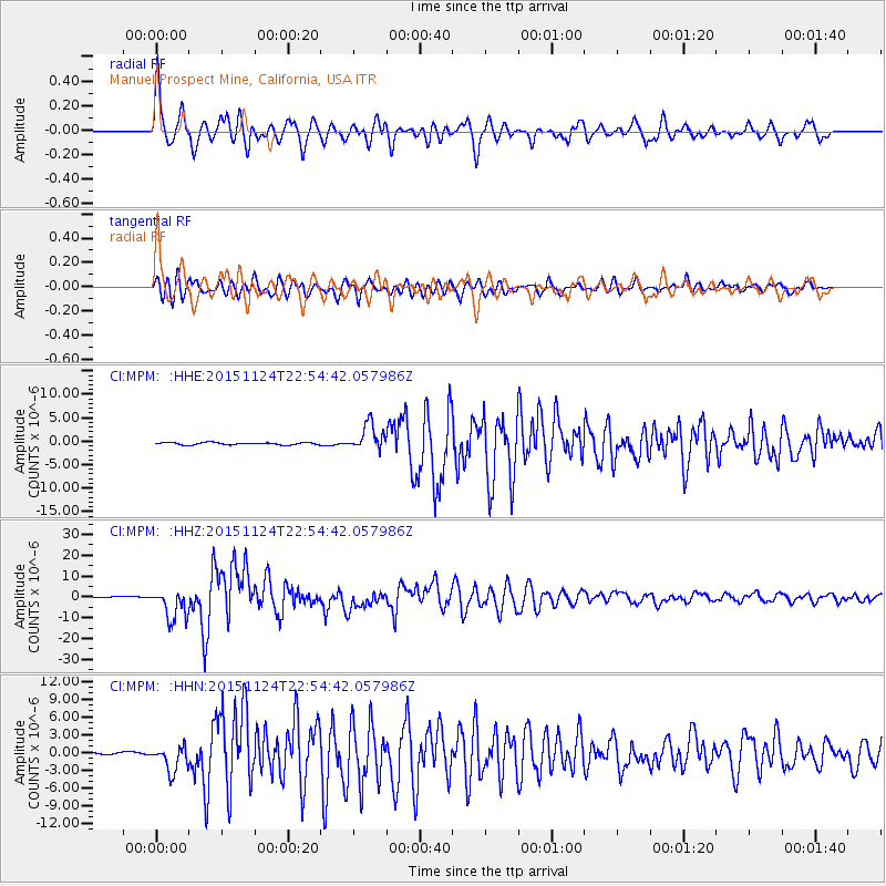
MPM Manuel Prospect Mine, California, USA - Earthquake Result Viewer
*The percent match for this event was below the threshold and hence no stack was calculated.
| Earthquake location: |
Peru-Brazil Border Region |
| Earthquake latitude/longitude: |
-10.6/-71.0 |
| Earthquake time(UTC): |
2015/11/24 (328) 22:45:38 GMT |
| Earthquake Depth: |
602 km |
| Earthquake Magnitude: |
7.5 MWW, 6.9 MI |
| Earthquake Catalog/Contributor: |
NEIC PDE/NEIC COMCAT |
|
| Network: |
CI Caltech Regional Seismic Network |
| Station: |
MPM Manuel Prospect Mine, California, USA |
| Lat/Lon: |
36.06 N/117.49 W |
| Elevation: |
185 m |
|
| Distance: |
63.8 deg |
| Az: |
319.063 deg |
| Baz: |
127.341 deg |
| Ray Param: |
$rayparam |
*The percent match for this event was below the threshold and hence was not used in the summary stack. |
|
| Radial Match: |
79.183945 % |
| Radial Bump: |
400 |
| Transverse Match: |
81.30022 % |
| Transverse Bump: |
400 |
| SOD ConfigId: |
7422571 |
| Insert Time: |
2019-04-21 11:26:26.469 +0000 |
| GWidth: |
2.5 |
| Max Bumps: |
400 |
| Tol: |
0.001 |
|
Signal To Noise
| Channel | StoN | STA | LTA |
| CI:MPM: :HHZ:20151124T22:54:42.057986Z | 23.541496 | 7.4766926E-6 | 3.1759632E-7 |
| CI:MPM: :HHN:20151124T22:54:42.057986Z | 18.286797 | 2.2002046E-6 | 1.2031657E-7 |
| CI:MPM: :HHE:20151124T22:54:42.057986Z | 11.347407 | 2.790318E-6 | 2.4589914E-7 |
| Arrivals |
| Ps | |
| PpPs | |
| PsPs/PpSs | |


