You are here: Home > Network List > CN - Canadian National Seismograph Network Stations List
> Station FRB IQALUIT, N.W.T. > Earthquake Result Viewer
FRB IQALUIT, N.W.T. - Earthquake Result Viewer

| Earthquake location: |
Peru-Brazil Border Region |
| Earthquake latitude/longitude: |
-10.6/-71.0 |
| Earthquake time(UTC): |
2015/11/24 (328) 22:45:38 GMT |
| Earthquake Depth: |
602 km |
| Earthquake Magnitude: |
7.5 MWW, 6.9 MI |
| Earthquake Catalog/Contributor: |
NEIC PDE/NEIC COMCAT |
|
| Network: |
CN Canadian National Seismograph Network |
| Station: |
FRB IQALUIT, N.W.T. |
| Lat/Lon: |
63.75 N/68.55 W |
| Elevation: |
18 m |
|
| Distance: |
74.1 deg |
| Az: |
1.118 deg |
| Baz: |
182.473 deg |
| Ray Param: |
0.05054431 |
| Estimated Moho Depth: |
41.5 km |
| Estimated Crust Vp/Vs: |
1.79 |
| Assumed Crust Vp: |
6.419 km/s |
| Estimated Crust Vs: |
3.586 km/s |
| Estimated Crust Poisson's Ratio: |
0.27 |
|
| Radial Match: |
94.85938 % |
| Radial Bump: |
400 |
| Transverse Match: |
85.27619 % |
| Transverse Bump: |
400 |
| SOD ConfigId: |
7422571 |
| Insert Time: |
2019-04-21 11:27:07.473 +0000 |
| GWidth: |
2.5 |
| Max Bumps: |
400 |
| Tol: |
0.001 |
|
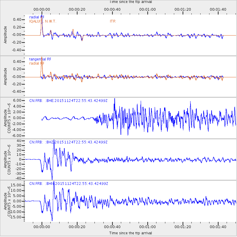
Signal To Noise
| Channel | StoN | STA | LTA |
| CN:FRB: :BHZ:20151124T22:55:43.42499Z | 23.994743 | 1.3489157E-5 | 5.6217135E-7 |
| CN:FRB: :BHN:20151124T22:55:43.42499Z | 15.715745 | 5.617683E-6 | 3.5745575E-7 |
| CN:FRB: :BHE:20151124T22:55:43.42499Z | 3.2806823 | 9.480965E-7 | 2.889937E-7 |
| Arrivals |
| Ps | 5.3 SECOND |
| PpPs | 17 SECOND |
| PsPs/PpSs | 23 SECOND |


