You are here: Home > Network List > CN - Canadian National Seismograph Network Stations List
> Station RES Resolute, NU, CA > Earthquake Result Viewer
RES Resolute, NU, CA - Earthquake Result Viewer
| Earthquake location: |
Peru-Brazil Border Region |
| Earthquake latitude/longitude: |
-10.6/-71.0 |
| Earthquake time(UTC): |
2015/11/24 (328) 22:45:38 GMT |
| Earthquake Depth: |
602 km |
| Earthquake Magnitude: |
7.5 MWW, 6.9 MI |
| Earthquake Catalog/Contributor: |
NEIC PDE/NEIC COMCAT |
|
| Network: |
CN Canadian National Seismograph Network |
| Station: |
RES Resolute, NU, CA |
| Lat/Lon: |
74.69 N/94.90 W |
| Elevation: |
19 m |
|
| Distance: |
86.4 deg |
| Az: |
353.8 deg |
| Baz: |
156.446 deg |
| Ray Param: |
0.042328082 |
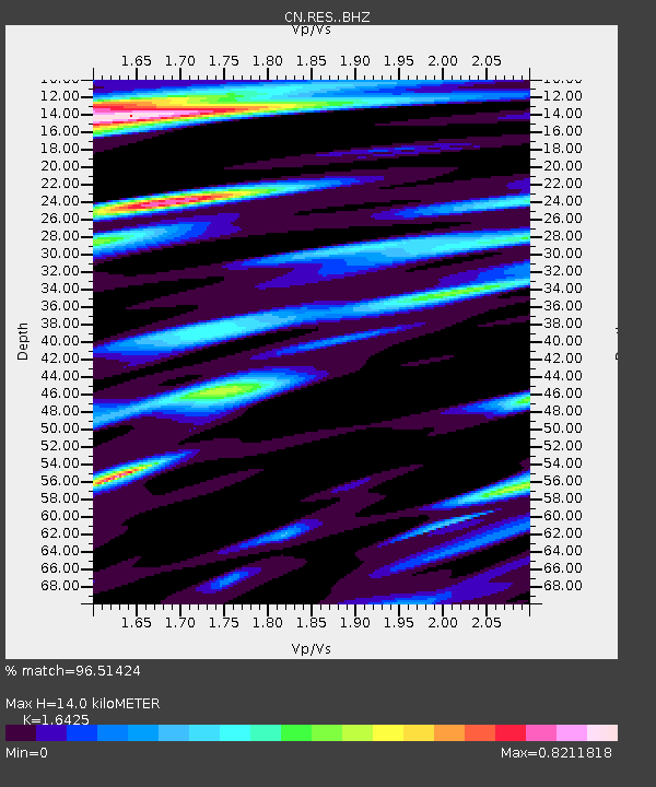
| Estimated Moho Depth: |
14.0 km |
| Estimated Crust Vp/Vs: |
1.64 |
| Assumed Crust Vp: |
6.367 km/s |
| Estimated Crust Vs: |
3.876 km/s |
| Estimated Crust Poisson's Ratio: |
0.21 |
|
| Radial Match: |
96.51424 % |
| Radial Bump: |
400 |
| Transverse Match: |
93.76276 % |
| Transverse Bump: |
400 |
| SOD ConfigId: |
7422571 |
| Insert Time: |
2019-04-21 11:27:31.580 +0000 |
| GWidth: |
2.5 |
| Max Bumps: |
400 |
| Tol: |
0.001 |
|
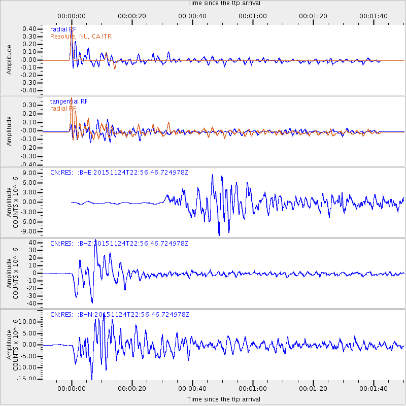
Signal To Noise
| Channel | StoN | STA | LTA |
| CN:RES: :BHZ:20151124T22:56:46.724978Z | 48.730698 | 1.3937413E-5 | 2.860089E-7 |
| CN:RES: :BHN:20151124T22:56:46.724978Z | 26.719616 | 3.5520748E-6 | 1.3293884E-7 |
| CN:RES: :BHE:20151124T22:56:46.724978Z | 5.9783072 | 1.1600215E-6 | 1.9403846E-7 |
| Arrivals |
| Ps | 1.4 SECOND |
| PpPs | 5.7 SECOND |
| PsPs/PpSs | 7.1 SECOND |


