You are here: Home > Network List > CN - Canadian National Seismograph Network Stations List
> Station VIB Van Inlet, BC, CA > Earthquake Result Viewer
VIB Van Inlet, BC, CA - Earthquake Result Viewer
| Earthquake location: |
Peru-Brazil Border Region |
| Earthquake latitude/longitude: |
-10.6/-71.0 |
| Earthquake time(UTC): |
2015/11/24 (328) 22:45:38 GMT |
| Earthquake Depth: |
602 km |
| Earthquake Magnitude: |
7.5 MWW, 6.9 MI |
| Earthquake Catalog/Contributor: |
NEIC PDE/NEIC COMCAT |
|
| Network: |
CN Canadian National Seismograph Network |
| Station: |
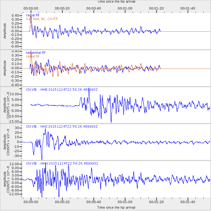
VIB Van Inlet, BC, CA |
| Lat/Lon: |
53.25 N/132.54 W |
| Elevation: |
1008 m |
|
| Distance: |
82.2 deg |
| Az: |
327.769 deg |
| Baz: |
119.226 deg |
| Ray Param: |
0.045216903 |
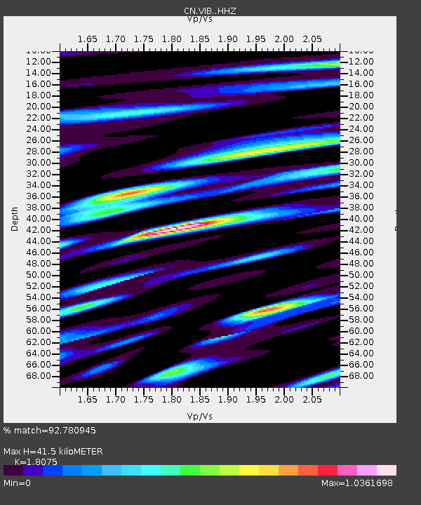
| Estimated Moho Depth: |
41.5 km |
| Estimated Crust Vp/Vs: |
1.81 |
| Assumed Crust Vp: |
6.183 km/s |
| Estimated Crust Vs: |
3.421 km/s |
| Estimated Crust Poisson's Ratio: |
0.28 |
|
| Radial Match: |
92.780945 % |
| Radial Bump: |
400 |
| Transverse Match: |
83.68637 % |
| Transverse Bump: |
400 |
| SOD ConfigId: |
7422571 |
| Insert Time: |
2019-04-21 11:27:38.962 +0000 |
| GWidth: |
2.5 |
| Max Bumps: |
400 |
| Tol: |
0.001 |
|
Signal To Noise
| Channel | StoN | STA | LTA |
| CN:VIB: :HHZ:20151124T22:56:26.489993Z | 25.010082 | 1.0205122E-5 | 4.080403E-7 |
| CN:VIB: :HHN:20151124T22:56:26.489993Z | 7.737075 | 3.3062038E-6 | 4.2731963E-7 |
| CN:VIB: :HHE:20151124T22:56:26.489993Z | 7.510671 | 3.2752494E-6 | 4.3607943E-7 |
| Arrivals |
| Ps | 5.5 SECOND |
| PpPs | 18 SECOND |
| PsPs/PpSs | 24 SECOND |


