You are here: Home > Network List > GE - GEOFON Stations List
> Station SNAA GEOFON/AWI Station Sanae, Antarctica > Earthquake Result Viewer
SNAA GEOFON/AWI Station Sanae, Antarctica - Earthquake Result Viewer
| Earthquake location: |
Peru-Brazil Border Region |
| Earthquake latitude/longitude: |
-10.6/-71.0 |
| Earthquake time(UTC): |
2015/11/24 (328) 22:45:38 GMT |
| Earthquake Depth: |
602 km |
| Earthquake Magnitude: |
7.5 MWW, 6.9 MI |
| Earthquake Catalog/Contributor: |
NEIC PDE/NEIC COMCAT |
|
| Network: |
GE GEOFON |
| Station: |
SNAA GEOFON/AWI Station Sanae, Antarctica |
| Lat/Lon: |
71.67 S/2.84 W |
| Elevation: |
846 m |
|
| Distance: |
73.2 deg |
| Az: |
162.14 deg |
| Baz: |
287.616 deg |
| Ray Param: |
0.051138006 |
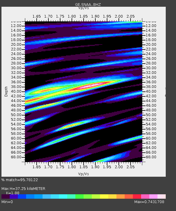
| Estimated Moho Depth: |
37.25 km |
| Estimated Crust Vp/Vs: |
1.88 |
| Assumed Crust Vp: |
6.43 km/s |
| Estimated Crust Vs: |
3.42 km/s |
| Estimated Crust Poisson's Ratio: |
0.30 |
|
| Radial Match: |
95.78122 % |
| Radial Bump: |
400 |
| Transverse Match: |
92.894615 % |
| Transverse Bump: |
400 |
| SOD ConfigId: |
7422571 |
| Insert Time: |
2019-04-21 11:28:22.113 +0000 |
| GWidth: |
2.5 |
| Max Bumps: |
400 |
| Tol: |
0.001 |
|
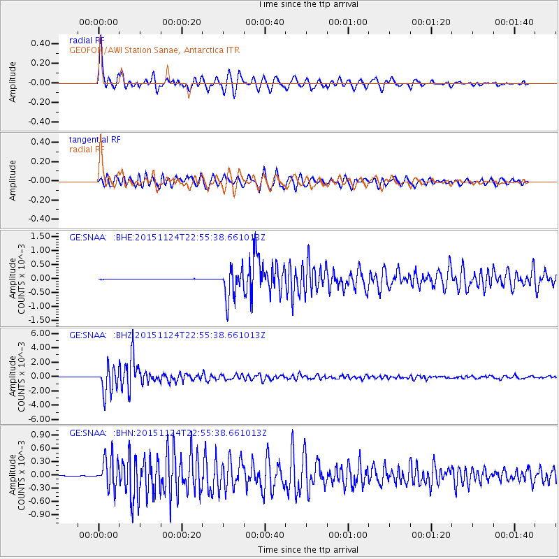
Signal To Noise
| Channel | StoN | STA | LTA |
| GE:SNAA: :BHZ:20151124T22:55:38.661013Z | 154.47754 | 0.0018349413 | 1.187837E-5 |
| GE:SNAA: :BHN:20151124T22:55:38.661013Z | 57.351875 | 3.4486604E-4 | 6.0131606E-6 |
| GE:SNAA: :BHE:20151124T22:55:38.661013Z | 78.26683 | 5.510129E-4 | 7.0401848E-6 |
| Arrivals |
| Ps | 5.3 SECOND |
| PpPs | 16 SECOND |
| PsPs/PpSs | 21 SECOND |


