You are here: Home > Network List > II - Global Seismograph Network (GSN - IRIS/IDA) Stations List
> Station CMLA Cha de Macela, Sao Miguel Island, Azores > Earthquake Result Viewer
CMLA Cha de Macela, Sao Miguel Island, Azores - Earthquake Result Viewer
| Earthquake location: |
Peru-Brazil Border Region |
| Earthquake latitude/longitude: |
-10.6/-71.0 |
| Earthquake time(UTC): |
2015/11/24 (328) 22:45:38 GMT |
| Earthquake Depth: |
602 km |
| Earthquake Magnitude: |
7.5 MWW, 6.9 MI |
| Earthquake Catalog/Contributor: |
NEIC PDE/NEIC COMCAT |
|
| Network: |
II Global Seismograph Network (GSN - IRIS/IDA) |
| Station: |
CMLA Cha de Macela, Sao Miguel Island, Azores |
| Lat/Lon: |
37.76 N/25.52 W |
| Elevation: |
429 m |
|
| Distance: |
64.2 deg |
| Az: |
38.851 deg |
| Baz: |
231.098 deg |
| Ray Param: |
0.05680205 |
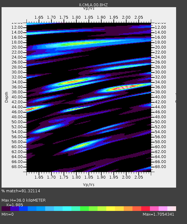
| Estimated Moho Depth: |
36.0 km |
| Estimated Crust Vp/Vs: |
1.99 |
| Assumed Crust Vp: |
4.802 km/s |
| Estimated Crust Vs: |
2.419 km/s |
| Estimated Crust Poisson's Ratio: |
0.33 |
|
| Radial Match: |
91.32114 % |
| Radial Bump: |
400 |
| Transverse Match: |
82.335266 % |
| Transverse Bump: |
400 |
| SOD ConfigId: |
7422571 |
| Insert Time: |
2019-04-21 11:28:48.273 +0000 |
| GWidth: |
2.5 |
| Max Bumps: |
400 |
| Tol: |
0.001 |
|
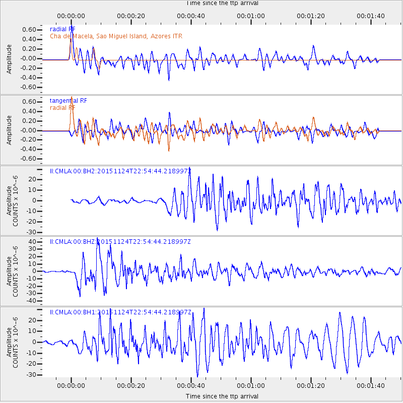
Signal To Noise
| Channel | StoN | STA | LTA |
| II:CMLA:00:BHZ:20151124T22:54:44.218997Z | 18.851667 | 1.438369E-5 | 7.6299295E-7 |
| II:CMLA:00:BH1:20151124T22:54:44.218997Z | 3.8074684 | 5.7594934E-6 | 1.5126832E-6 |
| II:CMLA:00:BH2:20151124T22:54:44.218997Z | 4.551174 | 6.9619655E-6 | 1.5297074E-6 |
| Arrivals |
| Ps | 7.5 SECOND |
| PpPs | 22 SECOND |
| PsPs/PpSs | 29 SECOND |


