You are here: Home > Network List > LD - Lamont-Doherty Cooperative Seismographic Network Stations List
> Station PAL Palisades, New York > Earthquake Result Viewer
PAL Palisades, New York - Earthquake Result Viewer
| Earthquake location: |
Peru-Brazil Border Region |
| Earthquake latitude/longitude: |
-10.6/-71.0 |
| Earthquake time(UTC): |
2015/11/24 (328) 22:45:38 GMT |
| Earthquake Depth: |
602 km |
| Earthquake Magnitude: |
7.5 MWW, 6.9 MI |
| Earthquake Catalog/Contributor: |
NEIC PDE/NEIC COMCAT |
|
| Network: |
LD Lamont-Doherty Cooperative Seismographic Network |
| Station: |
PAL Palisades, New York |
| Lat/Lon: |
41.01 N/73.91 W |
| Elevation: |
66 m |
|
| Distance: |
51.4 deg |
| Az: |
357.151 deg |
| Baz: |
176.298 deg |
| Ray Param: |
0.06465659 |
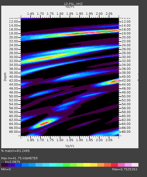
| Estimated Moho Depth: |
41.75 km |
| Estimated Crust Vp/Vs: |
2.10 |
| Assumed Crust Vp: |
6.472 km/s |
| Estimated Crust Vs: |
3.086 km/s |
| Estimated Crust Poisson's Ratio: |
0.35 |
|
| Radial Match: |
93.2495 % |
| Radial Bump: |
273 |
| Transverse Match: |
72.571045 % |
| Transverse Bump: |
400 |
| SOD ConfigId: |
7422571 |
| Insert Time: |
2019-04-21 11:29:22.159 +0000 |
| GWidth: |
2.5 |
| Max Bumps: |
400 |
| Tol: |
0.001 |
|

Signal To Noise
| Channel | StoN | STA | LTA |
| LD:PAL: :HHZ:20151124T22:53:18.148013Z | 23.428083 | 8.013931E-6 | 3.4206514E-7 |
| LD:PAL: :HHN:20151124T22:53:18.148013Z | 11.467792 | 4.830846E-6 | 4.212534E-7 |
| LD:PAL: :HHE:20151124T22:53:18.148013Z | 1.8150957 | 8.630623E-7 | 4.7549136E-7 |
| Arrivals |
| Ps | 7.4 SECOND |
| PpPs | 19 SECOND |
| PsPs/PpSs | 27 SECOND |


