You are here: Home > Network List > LD - Lamont-Doherty Cooperative Seismographic Network Stations List
> Station WUPA West Chester University of Pennsylvania > Earthquake Result Viewer
WUPA West Chester University of Pennsylvania - Earthquake Result Viewer

| Earthquake location: |
Peru-Brazil Border Region |
| Earthquake latitude/longitude: |
-10.6/-71.0 |
| Earthquake time(UTC): |
2015/11/24 (328) 22:45:38 GMT |
| Earthquake Depth: |
602 km |
| Earthquake Magnitude: |
7.5 MWW, 6.9 MI |
| Earthquake Catalog/Contributor: |
NEIC PDE/NEIC COMCAT |
|
| Network: |
LD Lamont-Doherty Cooperative Seismographic Network |
| Station: |
WUPA West Chester University of Pennsylvania |
| Lat/Lon: |
39.93 N/75.61 W |
| Elevation: |
86 m |
|
| Distance: |
50.4 deg |
| Az: |
355.372 deg |
| Baz: |
174.078 deg |
| Ray Param: |
0.06524963 |
| Estimated Moho Depth: |
21.0 km |
| Estimated Crust Vp/Vs: |
2.06 |
| Assumed Crust Vp: |
6.287 km/s |
| Estimated Crust Vs: |
3.06 km/s |
| Estimated Crust Poisson's Ratio: |
0.34 |
|
| Radial Match: |
92.36401 % |
| Radial Bump: |
252 |
| Transverse Match: |
67.001564 % |
| Transverse Bump: |
400 |
| SOD ConfigId: |
7422571 |
| Insert Time: |
2019-04-21 11:29:30.706 +0000 |
| GWidth: |
2.5 |
| Max Bumps: |
400 |
| Tol: |
0.001 |
|
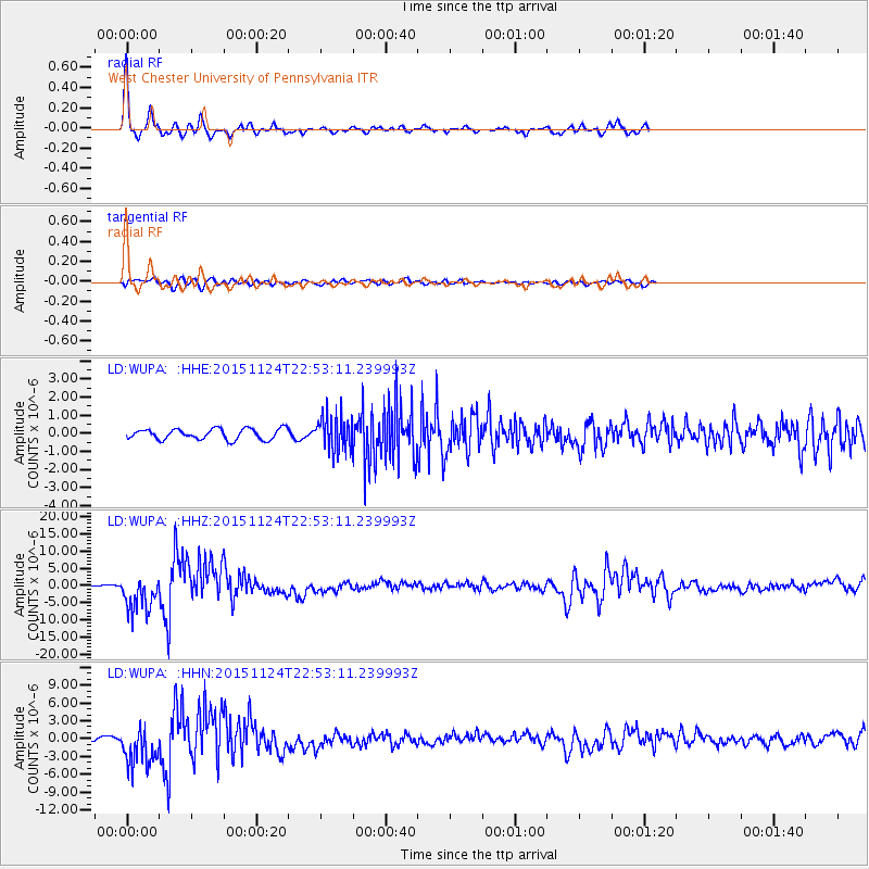
Signal To Noise
| Channel | StoN | STA | LTA |
| LD:WUPA: :HHZ:20151124T22:53:11.239993Z | 19.301304 | 5.354483E-6 | 2.7741564E-7 |
| LD:WUPA: :HHN:20151124T22:53:11.239993Z | 11.652581 | 3.4296925E-6 | 2.9432897E-7 |
| LD:WUPA: :HHE:20151124T22:53:11.239993Z | 3.2639859 | 9.533738E-7 | 2.9208883E-7 |
| Arrivals |
| Ps | 3.7 SECOND |
| PpPs | 9.8 SECOND |
| PsPs/PpSs | 13 SECOND |


