You are here: Home > Network List > N4 - Central and EAstern US Network Stations List
> Station F42A Maple Grove Farm, Niagara, WI, USA > Earthquake Result Viewer
F42A Maple Grove Farm, Niagara, WI, USA - Earthquake Result Viewer
| Earthquake location: |
Peru-Brazil Border Region |
| Earthquake latitude/longitude: |
-10.6/-71.0 |
| Earthquake time(UTC): |
2015/11/24 (328) 22:45:38 GMT |
| Earthquake Depth: |
602 km |
| Earthquake Magnitude: |
7.5 MWW, 6.9 MI |
| Earthquake Catalog/Contributor: |
NEIC PDE/NEIC COMCAT |
|
| Network: |
N4 Central and EAstern US Network |
| Station: |
F42A Maple Grove Farm, Niagara, WI, USA |
| Lat/Lon: |
45.76 N/88.13 W |
| Elevation: |
358 m |
|
| Distance: |
58.2 deg |
| Az: |
345.923 deg |
| Baz: |
160.026 deg |
| Ray Param: |
0.060515843 |
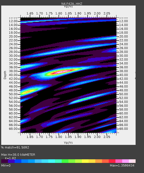
| Estimated Moho Depth: |
38.0 km |
| Estimated Crust Vp/Vs: |
1.82 |
| Assumed Crust Vp: |
6.41 km/s |
| Estimated Crust Vs: |
3.522 km/s |
| Estimated Crust Poisson's Ratio: |
0.28 |
|
| Radial Match: |
91.5892 % |
| Radial Bump: |
400 |
| Transverse Match: |
76.87221 % |
| Transverse Bump: |
400 |
| SOD ConfigId: |
7422571 |
| Insert Time: |
2019-04-21 11:30:07.652 +0000 |
| GWidth: |
2.5 |
| Max Bumps: |
400 |
| Tol: |
0.001 |
|

Signal To Noise
| Channel | StoN | STA | LTA |
| N4:F42A: :HHZ:20151124T22:54:05.169985Z | 35.75786 | 1.2264291E-5 | 3.4298174E-7 |
| N4:F42A: :HHN:20151124T22:54:05.169985Z | 24.811926 | 8.430192E-6 | 3.397637E-7 |
| N4:F42A: :HHE:20151124T22:54:05.169985Z | 28.207663 | 5.900875E-6 | 2.0919404E-7 |
| Arrivals |
| Ps | 5.1 SECOND |
| PpPs | 16 SECOND |
| PsPs/PpSs | 21 SECOND |


