You are here: Home > Network List > NE - New England Seismic Network Stations List
> Station YLE Yale, Connecticut, U.S.A. > Earthquake Result Viewer
YLE Yale, Connecticut, U.S.A. - Earthquake Result Viewer
| Earthquake location: |
Peru-Brazil Border Region |
| Earthquake latitude/longitude: |
-10.6/-71.0 |
| Earthquake time(UTC): |
2015/11/24 (328) 22:45:38 GMT |
| Earthquake Depth: |
602 km |
| Earthquake Magnitude: |
7.5 MWW, 6.9 MI |
| Earthquake Catalog/Contributor: |
NEIC PDE/NEIC COMCAT |
|
| Network: |
NE New England Seismic Network |
| Station: |
YLE Yale, Connecticut, U.S.A. |
| Lat/Lon: |
41.32 N/72.92 W |
| Elevation: |
41 m |
|
| Distance: |
51.7 deg |
| Az: |
358.122 deg |
| Baz: |
177.548 deg |
| Ray Param: |
0.064489275 |
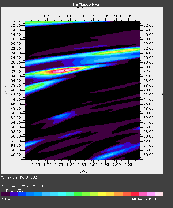
| Estimated Moho Depth: |
31.25 km |
| Estimated Crust Vp/Vs: |
1.77 |
| Assumed Crust Vp: |
6.472 km/s |
| Estimated Crust Vs: |
3.651 km/s |
| Estimated Crust Poisson's Ratio: |
0.27 |
|
| Radial Match: |
90.37032 % |
| Radial Bump: |
400 |
| Transverse Match: |
69.15256 % |
| Transverse Bump: |
400 |
| SOD ConfigId: |
7422571 |
| Insert Time: |
2019-04-21 11:31:44.297 +0000 |
| GWidth: |
2.5 |
| Max Bumps: |
400 |
| Tol: |
0.001 |
|

Signal To Noise
| Channel | StoN | STA | LTA |
| NE:YLE:00:HHZ:20151124T22:53:20.113986Z | 13.059287 | 1.1085366E-5 | 8.488492E-7 |
| NE:YLE:00:HH1:20151124T22:53:20.113986Z | 7.338245 | 6.44929E-6 | 8.788601E-7 |
| NE:YLE:00:HH2:20151124T22:53:20.113986Z | 1.5278687 | 1.5089992E-6 | 9.876497E-7 |
| Arrivals |
| Ps | 3.9 SECOND |
| PpPs | 13 SECOND |
| PsPs/PpSs | 17 SECOND |


