You are here: Home > Network List > NI - North-East Italy Broadband Network Stations List
> Station FUSE Fusea > Earthquake Result Viewer
FUSE Fusea - Earthquake Result Viewer
| Earthquake location: |
Peru-Brazil Border Region |
| Earthquake latitude/longitude: |
-10.6/-71.0 |
| Earthquake time(UTC): |
2015/11/24 (328) 22:45:38 GMT |
| Earthquake Depth: |
602 km |
| Earthquake Magnitude: |
7.5 MWW, 6.9 MI |
| Earthquake Catalog/Contributor: |
NEIC PDE/NEIC COMCAT |
|
| Network: |
NI North-East Italy Broadband Network |
| Station: |
FUSE Fusea |
| Lat/Lon: |
46.41 N/13.00 E |
| Elevation: |
520 m |
|
| Distance: |
93.5 deg |
| Az: |
43.574 deg |
| Baz: |
258.39 deg |
| Ray Param: |
0.040703412 |
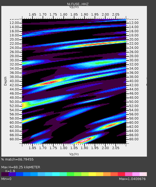
| Estimated Moho Depth: |
68.25 km |
| Estimated Crust Vp/Vs: |
1.90 |
| Assumed Crust Vp: |
6.35 km/s |
| Estimated Crust Vs: |
3.342 km/s |
| Estimated Crust Poisson's Ratio: |
0.31 |
|
| Radial Match: |
86.79455 % |
| Radial Bump: |
400 |
| Transverse Match: |
77.90831 % |
| Transverse Bump: |
400 |
| SOD ConfigId: |
7422571 |
| Insert Time: |
2019-04-21 11:31:45.202 +0000 |
| GWidth: |
2.5 |
| Max Bumps: |
400 |
| Tol: |
0.001 |
|

Signal To Noise
| Channel | StoN | STA | LTA |
| NI:FUSE: :HHZ:20151124T22:57:19.158022Z | 28.420933 | 5.590588E-6 | 1.9670671E-7 |
| NI:FUSE: :HHN:20151124T22:57:19.158022Z | 4.0329847 | 9.362261E-7 | 2.3214224E-7 |
| NI:FUSE: :HHE:20151124T22:57:19.158022Z | 8.933876 | 1.8210281E-6 | 2.0383405E-7 |
| Arrivals |
| Ps | 9.8 SECOND |
| PpPs | 31 SECOND |
| PsPs/PpSs | 40 SECOND |


