You are here: Home > Network List > NI - North-East Italy Broadband Network Stations List
> Station DRE Drenchia > Earthquake Result Viewer
DRE Drenchia - Earthquake Result Viewer
| Earthquake location: |
Peru-Brazil Border Region |
| Earthquake latitude/longitude: |
-10.6/-71.0 |
| Earthquake time(UTC): |
2015/11/24 (328) 22:45:38 GMT |
| Earthquake Depth: |
602 km |
| Earthquake Magnitude: |
7.5 MWW, 6.9 MI |
| Earthquake Catalog/Contributor: |
NEIC PDE/NEIC COMCAT |
|
| Network: |
NI North-East Italy Broadband Network |
| Station: |
DRE Drenchia |
| Lat/Lon: |
46.17 N/13.65 E |
| Elevation: |
810 m |
|
| Distance: |
93.8 deg |
| Az: |
43.899 deg |
| Baz: |
258.833 deg |
| Ray Param: |
0.040601596 |
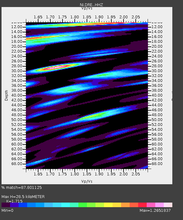
| Estimated Moho Depth: |
28.5 km |
| Estimated Crust Vp/Vs: |
1.72 |
| Assumed Crust Vp: |
6.35 km/s |
| Estimated Crust Vs: |
3.703 km/s |
| Estimated Crust Poisson's Ratio: |
0.24 |
|
| Radial Match: |
87.801125 % |
| Radial Bump: |
400 |
| Transverse Match: |
84.28291 % |
| Transverse Bump: |
400 |
| SOD ConfigId: |
7422571 |
| Insert Time: |
2019-04-21 11:31:45.289 +0000 |
| GWidth: |
2.5 |
| Max Bumps: |
400 |
| Tol: |
0.001 |
|

Signal To Noise
| Channel | StoN | STA | LTA |
| NI:DRE: :HHZ:20151124T22:57:20.917971Z | 16.685701 | 5.1975157E-6 | 3.114952E-7 |
| NI:DRE: :HHN:20151124T22:57:20.917971Z | 4.816124 | 8.329804E-7 | 1.7295659E-7 |
| NI:DRE: :HHE:20151124T22:57:20.917971Z | 6.892547 | 1.4855343E-6 | 2.1552762E-7 |
| Arrivals |
| Ps | 3.3 SECOND |
| PpPs | 12 SECOND |
| PsPs/PpSs | 15 SECOND |


