You are here: Home > Network List > NM - Cooperative New Madrid Seismic Network Stations List
> Station PVMO UM Delta Research Portageville, MO > Earthquake Result Viewer
PVMO UM Delta Research Portageville, MO - Earthquake Result Viewer
| Earthquake location: |
Peru-Brazil Border Region |
| Earthquake latitude/longitude: |
-10.6/-71.0 |
| Earthquake time(UTC): |
2015/11/24 (328) 22:45:38 GMT |
| Earthquake Depth: |
602 km |
| Earthquake Magnitude: |
7.5 MWW, 6.9 MI |
| Earthquake Catalog/Contributor: |
NEIC PDE/NEIC COMCAT |
|
| Network: |
NM Cooperative New Madrid Seismic Network |
| Station: |
PVMO UM Delta Research Portageville, MO |
| Lat/Lon: |
36.41 N/89.70 W |
| Elevation: |
98 m |
|
| Distance: |
50.0 deg |
| Az: |
340.223 deg |
| Baz: |
155.643 deg |
| Ray Param: |
0.06552931 |
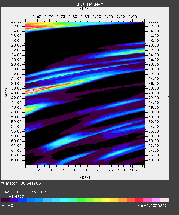
| Estimated Moho Depth: |
38.75 km |
| Estimated Crust Vp/Vs: |
1.63 |
| Assumed Crust Vp: |
6.444 km/s |
| Estimated Crust Vs: |
3.947 km/s |
| Estimated Crust Poisson's Ratio: |
0.20 |
|
| Radial Match: |
88.541985 % |
| Radial Bump: |
366 |
| Transverse Match: |
69.41872 % |
| Transverse Bump: |
338 |
| SOD ConfigId: |
7422571 |
| Insert Time: |
2019-04-21 11:31:53.470 +0000 |
| GWidth: |
2.5 |
| Max Bumps: |
400 |
| Tol: |
0.001 |
|

Signal To Noise
| Channel | StoN | STA | LTA |
| NM:PVMO: :HHZ:20151124T22:53:07.859988Z | 32.39667 | 3.228063E-5 | 9.964181E-7 |
| NM:PVMO: :HHN:20151124T22:53:07.859988Z | 15.92837 | 2.0784997E-5 | 1.3049042E-6 |
| NM:PVMO: :HHE:20151124T22:53:07.859988Z | 8.2561655 | 1.116806E-5 | 1.3526934E-6 |
| Arrivals |
| Ps | 4.0 SECOND |
| PpPs | 15 SECOND |
| PsPs/PpSs | 19 SECOND |


