You are here: Home > Network List > NN - Western Great Basin/Eastern Sierra Nevada Stations List
> Station RUB Rubicon Trail, California w84 > Earthquake Result Viewer
RUB Rubicon Trail, California w84 - Earthquake Result Viewer
| Earthquake location: |
Peru-Brazil Border Region |
| Earthquake latitude/longitude: |
-10.6/-71.0 |
| Earthquake time(UTC): |
2015/11/24 (328) 22:45:38 GMT |
| Earthquake Depth: |
602 km |
| Earthquake Magnitude: |
7.5 MWW, 6.9 MI |
| Earthquake Catalog/Contributor: |
NEIC PDE/NEIC COMCAT |
|
| Network: |
NN Western Great Basin/Eastern Sierra Nevada |
| Station: |
RUB Rubicon Trail, California w84 |
| Lat/Lon: |
39.05 N/120.15 W |
| Elevation: |
2045 m |
|
| Distance: |
67.3 deg |
| Az: |
320.298 deg |
| Baz: |
126.233 deg |
| Ray Param: |
0.054857906 |
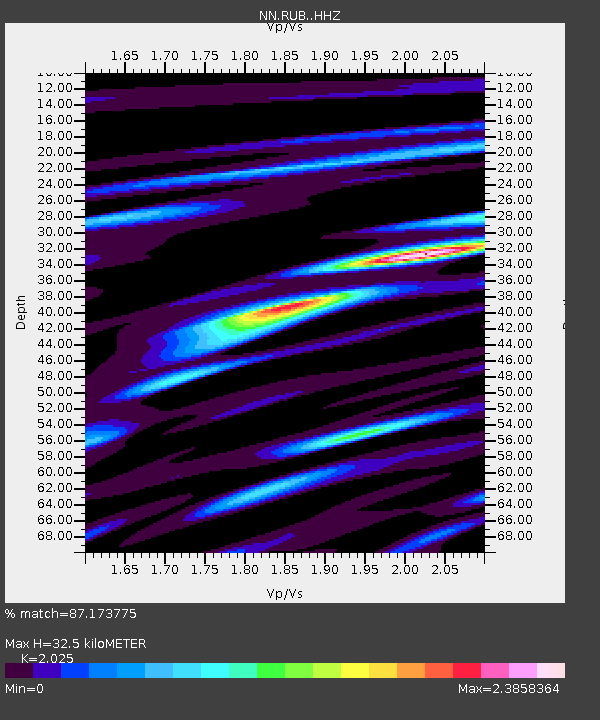
| Estimated Moho Depth: |
32.5 km |
| Estimated Crust Vp/Vs: |
2.03 |
| Assumed Crust Vp: |
6.597 km/s |
| Estimated Crust Vs: |
3.258 km/s |
| Estimated Crust Poisson's Ratio: |
0.34 |
|
| Radial Match: |
87.173775 % |
| Radial Bump: |
400 |
| Transverse Match: |
70.32298 % |
| Transverse Bump: |
400 |
| SOD ConfigId: |
7422571 |
| Insert Time: |
2019-04-21 11:32:09.594 +0000 |
| GWidth: |
2.5 |
| Max Bumps: |
400 |
| Tol: |
0.001 |
|

Signal To Noise
| Channel | StoN | STA | LTA |
| NN:RUB: :HHZ:20151124T22:55:03.66498Z | 23.059198 | 1.0667519E-5 | 4.6261445E-7 |
| NN:RUB: :HHN:20151124T22:55:03.66498Z | 5.0086327 | 2.8481302E-6 | 5.686442E-7 |
| NN:RUB: :HHE:20151124T22:55:03.66498Z | 8.888195 | 5.0913895E-6 | 5.728261E-7 |
| Arrivals |
| Ps | 5.2 SECOND |
| PpPs | 14 SECOND |
| PsPs/PpSs | 20 SECOND |


