You are here: Home > Network List > NX - Nanometrics Research Network Stations List
> Station STN10 Z > Earthquake Result Viewer
STN10 Z - Earthquake Result Viewer
| Earthquake location: |
Peru-Brazil Border Region |
| Earthquake latitude/longitude: |
-10.6/-71.0 |
| Earthquake time(UTC): |
2015/11/24 (328) 22:45:38 GMT |
| Earthquake Depth: |
602 km |
| Earthquake Magnitude: |
7.5 MWW, 6.9 MI |
| Earthquake Catalog/Contributor: |
NEIC PDE/NEIC COMCAT |
|
| Network: |
NX Nanometrics Research Network |
| Station: |
STN10 Z |
| Lat/Lon: |
36.15 N/96.94 W |
| Elevation: |
287 m |
|
| Distance: |
52.5 deg |
| Az: |
333.476 deg |
| Baz: |
147.149 deg |
| Ray Param: |
0.06396525 |
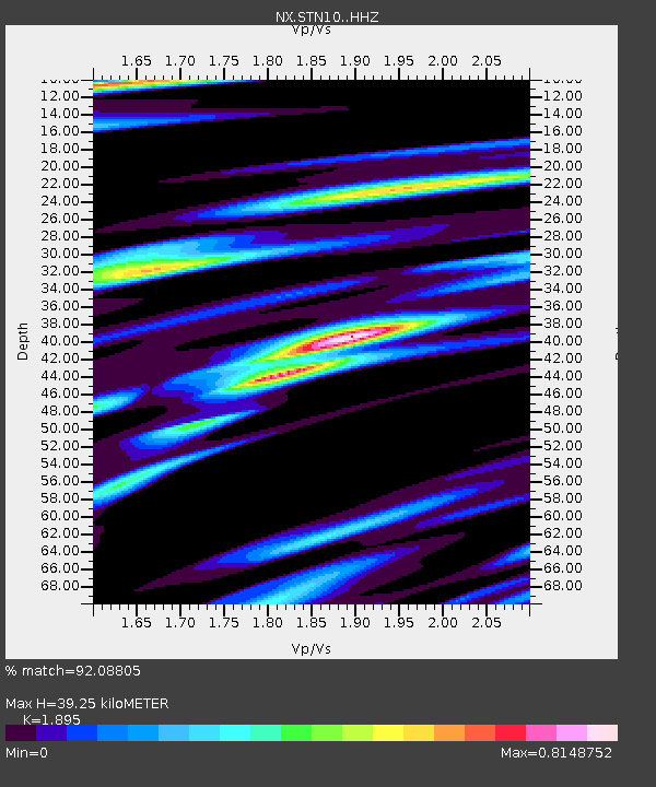
| Estimated Moho Depth: |
39.25 km |
| Estimated Crust Vp/Vs: |
1.89 |
| Assumed Crust Vp: |
6.483 km/s |
| Estimated Crust Vs: |
3.421 km/s |
| Estimated Crust Poisson's Ratio: |
0.31 |
|
| Radial Match: |
92.08805 % |
| Radial Bump: |
332 |
| Transverse Match: |
82.06712 % |
| Transverse Bump: |
400 |
| SOD ConfigId: |
7422571 |
| Insert Time: |
2019-04-21 11:32:29.598 +0000 |
| GWidth: |
2.5 |
| Max Bumps: |
400 |
| Tol: |
0.001 |
|

Signal To Noise
| Channel | StoN | STA | LTA |
| NX:STN10: :HHZ:20151124T22:53:26.329989Z | 84.48477 | 2.5719171E-5 | 3.0442374E-7 |
| NX:STN10: :HH1:20151124T22:53:26.329989Z | 29.205687 | 1.1173846E-5 | 3.8259145E-7 |
| NX:STN10: :HH2:20151124T22:53:26.329989Z | 6.562584 | 2.7743852E-6 | 4.2275803E-7 |
| Arrivals |
| Ps | 5.7 SECOND |
| PpPs | 17 SECOND |
| PsPs/PpSs | 22 SECOND |


