You are here: Home > Network List > ON - RSIS-Rede Sismografica do Sul e Sudeste Observatorio Nacional, Brazil Stations List
> Station ALF01 "OBSN: [ALF01] Guarapari, ES" > Earthquake Result Viewer
ALF01 "OBSN: [ALF01] Guarapari, ES" - Earthquake Result Viewer
| Earthquake location: |
Peru-Brazil Border Region |
| Earthquake latitude/longitude: |
-10.6/-71.0 |
| Earthquake time(UTC): |
2015/11/24 (328) 22:45:38 GMT |
| Earthquake Depth: |
602 km |
| Earthquake Magnitude: |
7.5 MWW, 6.9 MI |
| Earthquake Catalog/Contributor: |
NEIC PDE/NEIC COMCAT |
|
| Network: |
ON RSIS-Rede Sismografica do Sul e Sudeste Observatorio Nacional, Brazil |
| Station: |
ALF01 "OBSN: [ALF01] Guarapari, ES" |
| Lat/Lon: |
20.62 S/40.73 W |
| Elevation: |
22 m |
|
| Distance: |
30.7 deg |
| Az: |
112.611 deg |
| Baz: |
284.318 deg |
| Ray Param: |
0.07659313 |
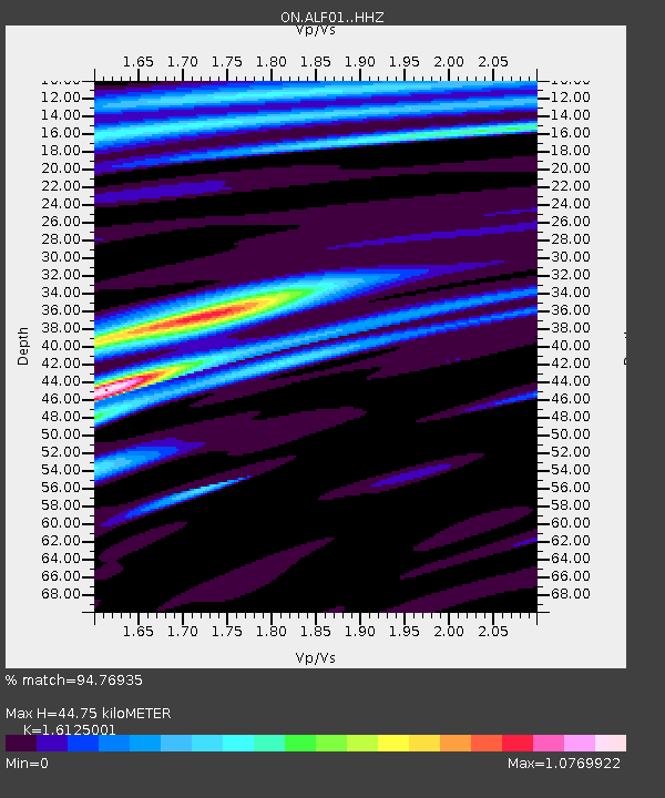
| Estimated Moho Depth: |
44.75 km |
| Estimated Crust Vp/Vs: |
1.61 |
| Assumed Crust Vp: |
6.472 km/s |
| Estimated Crust Vs: |
4.014 km/s |
| Estimated Crust Poisson's Ratio: |
0.19 |
|
| Radial Match: |
94.76935 % |
| Radial Bump: |
300 |
| Transverse Match: |
69.923904 % |
| Transverse Bump: |
400 |
| SOD ConfigId: |
7422571 |
| Insert Time: |
2019-04-21 11:33:04.818 +0000 |
| GWidth: |
2.5 |
| Max Bumps: |
400 |
| Tol: |
0.001 |
|

Signal To Noise
| Channel | StoN | STA | LTA |
| ON:ALF01: :HHZ:20151124T22:50:36.097994Z | 44.463203 | 1.2644509E-5 | 2.8438143E-7 |
| ON:ALF01: :HHN:20151124T22:50:36.097994Z | 9.787013 | 1.8758203E-6 | 1.9166423E-7 |
| ON:ALF01: :HHE:20151124T22:50:36.097994Z | 28.907045 | 6.7014353E-6 | 2.3182706E-7 |
| Arrivals |
| Ps | 4.6 SECOND |
| PpPs | 17 SECOND |
| PsPs/PpSs | 21 SECOND |


