You are here: Home > Network List > PB - Plate Boundary Observatory Borehole Seismic Network Stations List
> Station B087 fordra087bcs2006, Anza, CA, USA > Earthquake Result Viewer
B087 fordra087bcs2006, Anza, CA, USA - Earthquake Result Viewer
| Earthquake location: |
Peru-Brazil Border Region |
| Earthquake latitude/longitude: |
-10.6/-71.0 |
| Earthquake time(UTC): |
2015/11/24 (328) 22:45:38 GMT |
| Earthquake Depth: |
602 km |
| Earthquake Magnitude: |
7.5 MWW, 6.9 MI |
| Earthquake Catalog/Contributor: |
NEIC PDE/NEIC COMCAT |
|
| Network: |
PB Plate Boundary Observatory Borehole Seismic Network |
| Station: |
B087 fordra087bcs2006, Anza, CA, USA |
| Lat/Lon: |
33.50 N/116.60 W |
| Elevation: |
1139 m |
|
| Distance: |
61.7 deg |
| Az: |
317.269 deg |
| Baz: |
127.022 deg |
| Ray Param: |
0.058351185 |
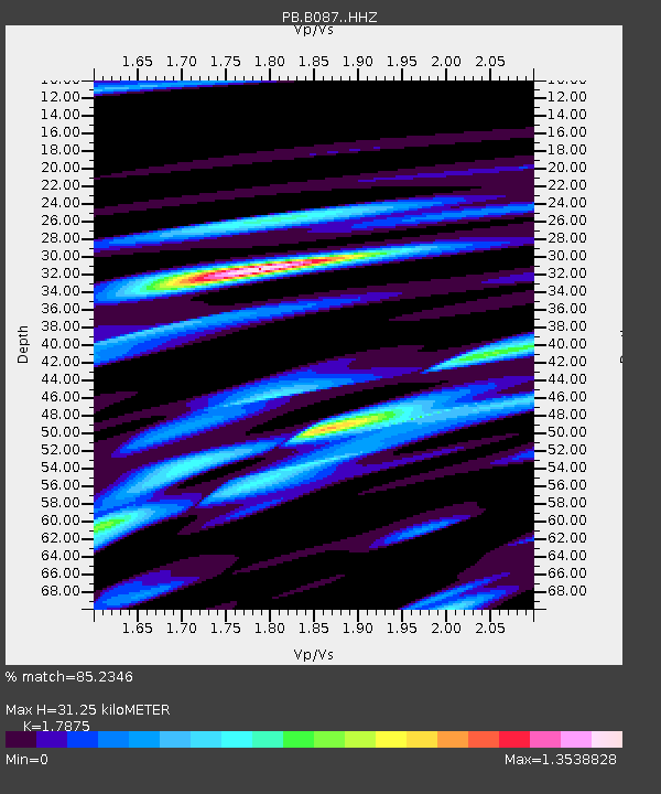
| Estimated Moho Depth: |
31.25 km |
| Estimated Crust Vp/Vs: |
1.79 |
| Assumed Crust Vp: |
6.264 km/s |
| Estimated Crust Vs: |
3.504 km/s |
| Estimated Crust Poisson's Ratio: |
0.27 |
|
| Radial Match: |
85.2346 % |
| Radial Bump: |
400 |
| Transverse Match: |
81.583595 % |
| Transverse Bump: |
400 |
| SOD ConfigId: |
7422571 |
| Insert Time: |
2019-04-21 11:33:12.262 +0000 |
| GWidth: |
2.5 |
| Max Bumps: |
400 |
| Tol: |
0.001 |
|

Signal To Noise
| Channel | StoN | STA | LTA |
| PB:B087: :HHZ:20151124T22:54:28.474001Z | 200.86563 | 6.4246785E-7 | 3.1984957E-9 |
| PB:B087: :HH1:20151124T22:54:28.474001Z | 18.937157 | 8.200887E-8 | 4.33058E-9 |
| PB:B087: :HH2:20151124T22:54:28.474001Z | 28.6186 | 9.5477546E-8 | 3.336206E-9 |
| Arrivals |
| Ps | 4.1 SECOND |
| PpPs | 13 SECOND |
| PsPs/PpSs | 17 SECOND |


