You are here: Home > Network List > PO - Portable Observatories for Lithospheric Analysis and Research Investigating Seis Stations List
> Station CHGQ Chibougamau, QC > Earthquake Result Viewer
CHGQ Chibougamau, QC - Earthquake Result Viewer
| Earthquake location: |
Peru-Brazil Border Region |
| Earthquake latitude/longitude: |
-10.6/-71.0 |
| Earthquake time(UTC): |
2015/11/24 (328) 22:45:38 GMT |
| Earthquake Depth: |
602 km |
| Earthquake Magnitude: |
7.5 MWW, 6.9 MI |
| Earthquake Catalog/Contributor: |
NEIC PDE/NEIC COMCAT |
|
| Network: |
PO Portable Observatories for Lithospheric Analysis and Research Investigating Seis |
| Station: |
CHGQ Chibougamau, QC |
| Lat/Lon: |
49.91 N/74.37 W |
| Elevation: |
406 m |
|
| Distance: |
60.3 deg |
| Az: |
357.463 deg |
| Baz: |
176.141 deg |
| Ray Param: |
0.059199546 |
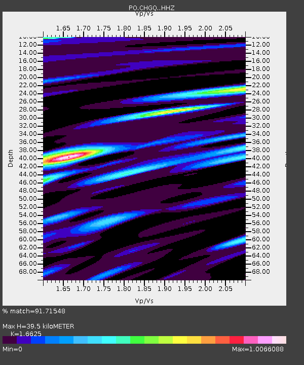
| Estimated Moho Depth: |
39.5 km |
| Estimated Crust Vp/Vs: |
1.66 |
| Assumed Crust Vp: |
6.61 km/s |
| Estimated Crust Vs: |
3.976 km/s |
| Estimated Crust Poisson's Ratio: |
0.22 |
|
| Radial Match: |
91.71548 % |
| Radial Bump: |
400 |
| Transverse Match: |
69.289116 % |
| Transverse Bump: |
400 |
| SOD ConfigId: |
7422571 |
| Insert Time: |
2019-04-21 11:33:24.363 +0000 |
| GWidth: |
2.5 |
| Max Bumps: |
400 |
| Tol: |
0.001 |
|

Signal To Noise
| Channel | StoN | STA | LTA |
| PO:CHGQ: :HHZ:20151124T22:54:19.310Z | 9.568861 | 1.1020688E-5 | 1.1517242E-6 |
| PO:CHGQ: :HHN:20151124T22:54:19.310Z | 11.116469 | 4.876017E-6 | 4.3863002E-7 |
| PO:CHGQ: :HHE:20151124T22:54:19.310Z | 1.3752176 | 1.3622981E-6 | 9.906056E-7 |
| Arrivals |
| Ps | 4.2 SECOND |
| PpPs | 15 SECOND |
| PsPs/PpSs | 19 SECOND |


