You are here: Home > Network List > SV - Servicio Nacional de Estudios Territoriales (SNET), El Salvador Stations List
> Station MTO3 Montecristo > Earthquake Result Viewer
MTO3 Montecristo - Earthquake Result Viewer
| Earthquake location: |
Peru-Brazil Border Region |
| Earthquake latitude/longitude: |
-10.6/-71.0 |
| Earthquake time(UTC): |
2015/11/24 (328) 22:45:38 GMT |
| Earthquake Depth: |
602 km |
| Earthquake Magnitude: |
7.5 MWW, 6.9 MI |
| Earthquake Catalog/Contributor: |
NEIC PDE/NEIC COMCAT |
|
| Network: |
SV Servicio Nacional de Estudios Territoriales (SNET), El Salvador |
| Station: |
MTO3 Montecristo |
| Lat/Lon: |
14.40 N/89.36 W |
| Elevation: |
1830 m |
|
| Distance: |
30.8 deg |
| Az: |
323.335 deg |
| Baz: |
142.707 deg |
| Ray Param: |
0.07655883 |
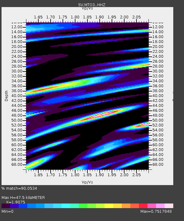
| Estimated Moho Depth: |
47.5 km |
| Estimated Crust Vp/Vs: |
1.91 |
| Assumed Crust Vp: |
6.597 km/s |
| Estimated Crust Vs: |
3.459 km/s |
| Estimated Crust Poisson's Ratio: |
0.31 |
|
| Radial Match: |
90.0534 % |
| Radial Bump: |
400 |
| Transverse Match: |
78.914696 % |
| Transverse Bump: |
400 |
| SOD ConfigId: |
7422571 |
| Insert Time: |
2019-04-21 11:33:56.811 +0000 |
| GWidth: |
2.5 |
| Max Bumps: |
400 |
| Tol: |
0.001 |
|

Signal To Noise
| Channel | StoN | STA | LTA |
| SV:MTO3: :HHZ:20151124T22:50:36.488009Z | 43.047832 | 7.741849E-6 | 1.7984296E-7 |
| SV:MTO3: :HHN:20151124T22:50:36.488009Z | 10.887059 | 3.4954953E-6 | 3.2106882E-7 |
| SV:MTO3: :HHE:20151124T22:50:36.488009Z | 9.586838 | 2.4673311E-6 | 2.573665E-7 |
| Arrivals |
| Ps | 7.0 SECOND |
| PpPs | 19 SECOND |
| PsPs/PpSs | 26 SECOND |


