You are here: Home > Network List > TA - USArray Transportable Network (new EarthScope stations) Stations List
> Station I04A Tendick Farm, Oakridge, OR, USA > Earthquake Result Viewer
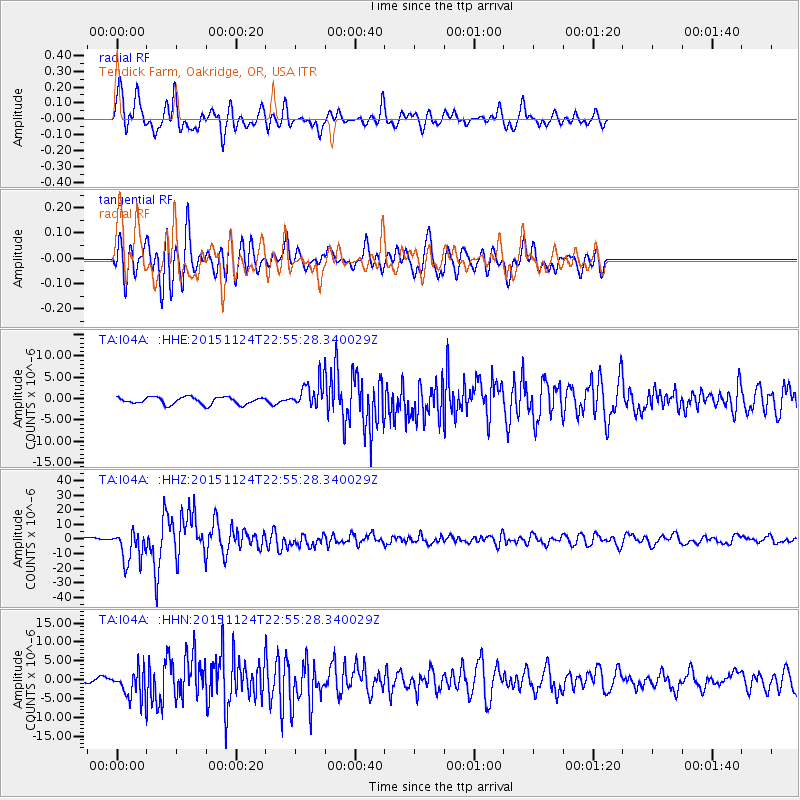
I04A Tendick Farm, Oakridge, OR, USA - Earthquake Result Viewer
| Earthquake location: |
Peru-Brazil Border Region |
| Earthquake latitude/longitude: |
-10.6/-71.0 |
| Earthquake time(UTC): |
2015/11/24 (328) 22:45:38 GMT |
| Earthquake Depth: |
602 km |
| Earthquake Magnitude: |
7.5 MWW, 6.9 MI |
| Earthquake Catalog/Contributor: |
NEIC PDE/NEIC COMCAT |
|
| Network: |
TA USArray Transportable Network (new EarthScope stations) |
| Station: |
I04A Tendick Farm, Oakridge, OR, USA |
| Lat/Lon: |
43.79 N/122.41 W |
| Elevation: |
731 m |
|
| Distance: |
71.5 deg |
| Az: |
323.325 deg |
| Baz: |
125.811 deg |
| Ray Param: |
0.052242145 |
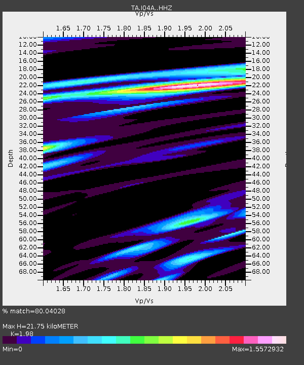
| Estimated Moho Depth: |
21.75 km |
| Estimated Crust Vp/Vs: |
1.98 |
| Assumed Crust Vp: |
6.522 km/s |
| Estimated Crust Vs: |
3.294 km/s |
| Estimated Crust Poisson's Ratio: |
0.33 |
|
| Radial Match: |
80.04028 % |
| Radial Bump: |
400 |
| Transverse Match: |
73.31858 % |
| Transverse Bump: |
400 |
| SOD ConfigId: |
7422571 |
| Insert Time: |
2019-04-21 11:34:21.418 +0000 |
| GWidth: |
2.5 |
| Max Bumps: |
400 |
| Tol: |
0.001 |
|
Signal To Noise
| Channel | StoN | STA | LTA |
| TA:I04A: :HHZ:20151124T22:55:28.340029Z | 13.370514 | 1.111043E-5 | 8.3096506E-7 |
| TA:I04A: :HHN:20151124T22:55:28.340029Z | 5.3214774 | 3.7162033E-6 | 6.983405E-7 |
| TA:I04A: :HHE:20151124T22:55:28.340029Z | 3.3308244 | 2.8444808E-6 | 8.5398705E-7 |
| Arrivals |
| Ps | 3.4 SECOND |
| PpPs | 9.6 SECOND |
| PsPs/PpSs | 13 SECOND |


