You are here: Home > Network List > TA - USArray Transportable Network (new EarthScope stations) Stations List
> Station J04D Umpqua National Forest, Toketee, OR, USA > Earthquake Result Viewer
J04D Umpqua National Forest, Toketee, OR, USA - Earthquake Result Viewer
| Earthquake location: |
Peru-Brazil Border Region |
| Earthquake latitude/longitude: |
-10.6/-71.0 |
| Earthquake time(UTC): |
2015/11/24 (328) 22:45:38 GMT |
| Earthquake Depth: |
602 km |
| Earthquake Magnitude: |
7.5 MWW, 6.9 MI |
| Earthquake Catalog/Contributor: |
NEIC PDE/NEIC COMCAT |
|
| Network: |
TA USArray Transportable Network (new EarthScope stations) |
| Station: |
J04D Umpqua National Forest, Toketee, OR, USA |
| Lat/Lon: |
43.24 N/122.11 W |
| Elevation: |
1948 m |
|
| Distance: |
71.0 deg |
| Az: |
322.987 deg |
| Baz: |
125.909 deg |
| Ray Param: |
0.052562684 |
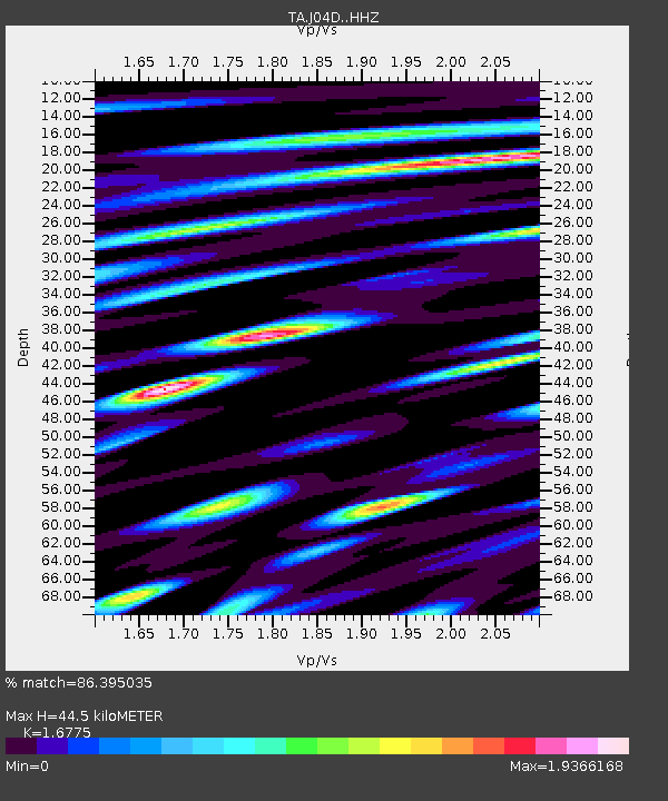
| Estimated Moho Depth: |
44.5 km |
| Estimated Crust Vp/Vs: |
1.68 |
| Assumed Crust Vp: |
6.522 km/s |
| Estimated Crust Vs: |
3.888 km/s |
| Estimated Crust Poisson's Ratio: |
0.22 |
|
| Radial Match: |
86.395035 % |
| Radial Bump: |
400 |
| Transverse Match: |
80.90036 % |
| Transverse Bump: |
400 |
| SOD ConfigId: |
7422571 |
| Insert Time: |
2019-04-21 11:34:25.706 +0000 |
| GWidth: |
2.5 |
| Max Bumps: |
400 |
| Tol: |
0.001 |
|

Signal To Noise
| Channel | StoN | STA | LTA |
| TA:J04D: :HHZ:20151124T22:55:25.419985Z | 27.982498 | 1.9397587E-5 | 6.9320424E-7 |
| TA:J04D: :HHN:20151124T22:55:25.419985Z | 8.912403 | 8.082095E-6 | 9.068367E-7 |
| TA:J04D: :HHE:20151124T22:55:25.419985Z | 6.778719 | 6.8795657E-6 | 1.014877E-6 |
| Arrivals |
| Ps | 4.8 SECOND |
| PpPs | 18 SECOND |
| PsPs/PpSs | 22 SECOND |


