You are here: Home > Network List > TA - USArray Transportable Network (new EarthScope stations) Stations List
> Station N25K Chitina, Valdez-Cordova, AK, USA > Earthquake Result Viewer
N25K Chitina, Valdez-Cordova, AK, USA - Earthquake Result Viewer
| Earthquake location: |
Peru-Brazil Border Region |
| Earthquake latitude/longitude: |
-10.6/-71.0 |
| Earthquake time(UTC): |
2015/11/24 (328) 22:45:38 GMT |
| Earthquake Depth: |
602 km |
| Earthquake Magnitude: |
7.5 MWW, 6.9 MI |
| Earthquake Catalog/Contributor: |
NEIC PDE/NEIC COMCAT |
|
| Network: |
TA USArray Transportable Network (new EarthScope stations) |
| Station: |
N25K Chitina, Valdez-Cordova, AK, USA |
| Lat/Lon: |
61.61 N/144.60 W |
| Elevation: |
1087 m |
|
| Distance: |
91.6 deg |
| Az: |
332.69 deg |
| Baz: |
109.313 deg |
| Ray Param: |
0.041166212 |
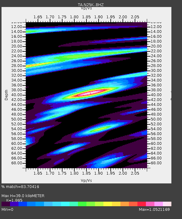
| Estimated Moho Depth: |
39.0 km |
| Estimated Crust Vp/Vs: |
1.87 |
| Assumed Crust Vp: |
6.566 km/s |
| Estimated Crust Vs: |
3.521 km/s |
| Estimated Crust Poisson's Ratio: |
0.30 |
|
| Radial Match: |
83.70416 % |
| Radial Bump: |
400 |
| Transverse Match: |
79.267166 % |
| Transverse Bump: |
400 |
| SOD ConfigId: |
7422571 |
| Insert Time: |
2019-04-21 11:34:52.022 +0000 |
| GWidth: |
2.5 |
| Max Bumps: |
400 |
| Tol: |
0.001 |
|
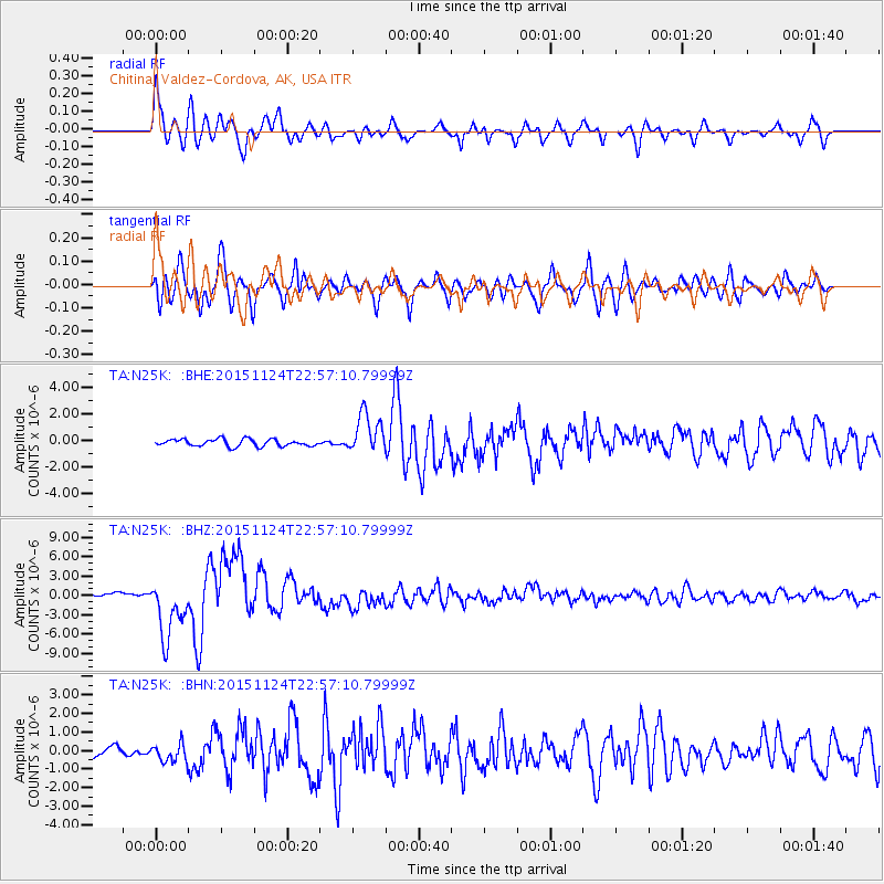
Signal To Noise
| Channel | StoN | STA | LTA |
| TA:N25K: :BHZ:20151124T22:57:10.79999Z | 17.90836 | 4.562487E-6 | 2.5476854E-7 |
| TA:N25K: :BHN:20151124T22:57:10.79999Z | 1.5391276 | 4.891196E-7 | 3.1779015E-7 |
| TA:N25K: :BHE:20151124T22:57:10.79999Z | 5.519005 | 1.4954653E-6 | 2.7096647E-7 |
| Arrivals |
| Ps | 5.2 SECOND |
| PpPs | 17 SECOND |
| PsPs/PpSs | 22 SECOND |


