You are here: Home > Network List > TA - USArray Transportable Network (new EarthScope stations) Stations List
> Station T25A Trinidad, CO, USA > Earthquake Result Viewer
T25A Trinidad, CO, USA - Earthquake Result Viewer
| Earthquake location: |
Peru-Brazil Border Region |
| Earthquake latitude/longitude: |
-10.6/-71.0 |
| Earthquake time(UTC): |
2015/11/24 (328) 22:45:38 GMT |
| Earthquake Depth: |
602 km |
| Earthquake Magnitude: |
7.5 MWW, 6.9 MI |
| Earthquake Catalog/Contributor: |
NEIC PDE/NEIC COMCAT |
|
| Network: |
TA USArray Transportable Network (new EarthScope stations) |
| Station: |
T25A Trinidad, CO, USA |
| Lat/Lon: |
37.14 N/104.41 W |
| Elevation: |
2017 m |
|
| Distance: |
56.9 deg |
| Az: |
328.287 deg |
| Baz: |
139.703 deg |
| Ray Param: |
0.06128299 |
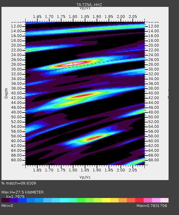
| Estimated Moho Depth: |
27.5 km |
| Estimated Crust Vp/Vs: |
1.80 |
| Assumed Crust Vp: |
6.316 km/s |
| Estimated Crust Vs: |
3.514 km/s |
| Estimated Crust Poisson's Ratio: |
0.28 |
|
| Radial Match: |
89.8309 % |
| Radial Bump: |
312 |
| Transverse Match: |
75.839195 % |
| Transverse Bump: |
353 |
| SOD ConfigId: |
7422571 |
| Insert Time: |
2019-04-21 11:35:14.684 +0000 |
| GWidth: |
2.5 |
| Max Bumps: |
400 |
| Tol: |
0.001 |
|

Signal To Noise
| Channel | StoN | STA | LTA |
| TA:T25A: :HHZ:20151124T22:53:56.750002Z | 29.012604 | 1.0429464E-5 | 3.5948048E-7 |
| TA:T25A: :HHN:20151124T22:53:56.750002Z | 10.178041 | 3.5499468E-6 | 3.4878485E-7 |
| TA:T25A: :HHE:20151124T22:53:56.750002Z | 10.75794 | 3.2187845E-6 | 2.9920082E-7 |
| Arrivals |
| Ps | 3.6 SECOND |
| PpPs | 12 SECOND |
| PsPs/PpSs | 15 SECOND |


