You are here: Home > Network List > UO - University of Oregon Regional Network Stations List
> Station DBO Dodson Butte, OR (UO CREST BB SMO) > Earthquake Result Viewer
DBO Dodson Butte, OR (UO CREST BB SMO) - Earthquake Result Viewer
| Earthquake location: |
Peru-Brazil Border Region |
| Earthquake latitude/longitude: |
-10.6/-71.0 |
| Earthquake time(UTC): |
2015/11/24 (328) 22:45:38 GMT |
| Earthquake Depth: |
602 km |
| Earthquake Magnitude: |
7.5 MWW, 6.9 MI |
| Earthquake Catalog/Contributor: |
NEIC PDE/NEIC COMCAT |
|
| Network: |
UO University of Oregon Regional Network |
| Station: |
DBO Dodson Butte, OR (UO CREST BB SMO) |
| Lat/Lon: |
43.12 N/123.24 W |
| Elevation: |
984 m |
|
| Distance: |
71.6 deg |
| Az: |
322.374 deg |
| Baz: |
124.939 deg |
| Ray Param: |
0.052175947 |
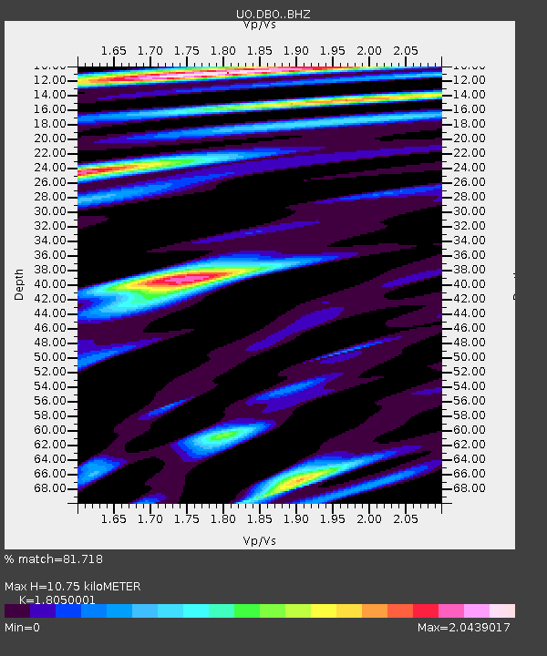
| Estimated Moho Depth: |
10.75 km |
| Estimated Crust Vp/Vs: |
1.81 |
| Assumed Crust Vp: |
6.522 km/s |
| Estimated Crust Vs: |
3.613 km/s |
| Estimated Crust Poisson's Ratio: |
0.28 |
|
| Radial Match: |
81.718 % |
| Radial Bump: |
400 |
| Transverse Match: |
81.38911 % |
| Transverse Bump: |
400 |
| SOD ConfigId: |
7422571 |
| Insert Time: |
2019-04-21 11:35:33.453 +0000 |
| GWidth: |
2.5 |
| Max Bumps: |
400 |
| Tol: |
0.001 |
|

Signal To Noise
| Channel | StoN | STA | LTA |
| UO:DBO: :BHZ:20151124T22:55:28.940005Z | 10.676355 | 1.3895863E-5 | 1.3015549E-6 |
| UO:DBO: :BHN:20151124T22:55:28.940005Z | 5.540046 | 7.0943934E-6 | 1.2805658E-6 |
| UO:DBO: :BHE:20151124T22:55:28.940005Z | 2.7534628 | 5.758427E-6 | 2.09134E-6 |
| Arrivals |
| Ps | 1.4 SECOND |
| PpPs | 4.5 SECOND |
| PsPs/PpSs | 5.8 SECOND |


