You are here: Home > Network List > US - United States National Seismic Network Stations List
> Station DGMT Dagmar, Montana, USA > Earthquake Result Viewer
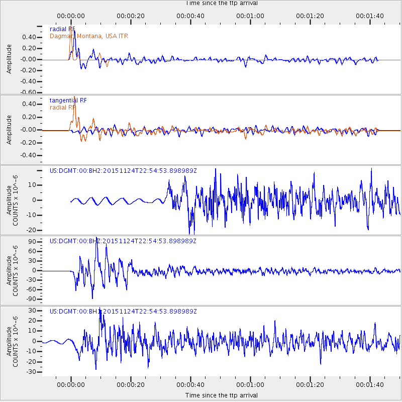
DGMT Dagmar, Montana, USA - Earthquake Result Viewer
*The percent match for this event was below the threshold and hence no stack was calculated.
| Earthquake location: |
Peru-Brazil Border Region |
| Earthquake latitude/longitude: |
-10.6/-71.0 |
| Earthquake time(UTC): |
2015/11/24 (328) 22:45:38 GMT |
| Earthquake Depth: |
602 km |
| Earthquake Magnitude: |
7.5 MWW, 6.9 MI |
| Earthquake Catalog/Contributor: |
NEIC PDE/NEIC COMCAT |
|
| Network: |
US United States National Seismic Network |
| Station: |
DGMT Dagmar, Montana, USA |
| Lat/Lon: |
48.47 N/104.20 W |
| Elevation: |
0.0 m |
|
| Distance: |
65.7 deg |
| Az: |
336.418 deg |
| Baz: |
143.768 deg |
| Ray Param: |
$rayparam |
*The percent match for this event was below the threshold and hence was not used in the summary stack. |
|
| Radial Match: |
94.79841 % |
| Radial Bump: |
400 |
| Transverse Match: |
82.89553 % |
| Transverse Bump: |
400 |
| SOD ConfigId: |
7422571 |
| Insert Time: |
2019-04-21 11:35:37.182 +0000 |
| GWidth: |
2.5 |
| Max Bumps: |
400 |
| Tol: |
0.001 |
|
Signal To Noise
| Channel | StoN | STA | LTA |
| US:DGMT:00:BHZ:20151124T22:54:53.898989Z | 51.666927 | 2.5558375E-5 | 4.946757E-7 |
| US:DGMT:00:BH1:20151124T22:54:53.898989Z | 11.954198 | 7.4029676E-6 | 6.1927767E-7 |
| US:DGMT:00:BH2:20151124T22:54:53.898989Z | 3.2697759 | 4.7903077E-6 | 1.4650263E-6 |
| Arrivals |
| Ps | |
| PpPs | |
| PsPs/PpSs | |


