You are here: Home > Network List > US - United States National Seismic Network Stations List
> Station NLWA Neilton Lookout, Washington, USA > Earthquake Result Viewer
NLWA Neilton Lookout, Washington, USA - Earthquake Result Viewer
| Earthquake location: |
Peru-Brazil Border Region |
| Earthquake latitude/longitude: |
-10.6/-71.0 |
| Earthquake time(UTC): |
2015/11/24 (328) 22:45:38 GMT |
| Earthquake Depth: |
602 km |
| Earthquake Magnitude: |
7.5 MWW, 6.9 MI |
| Earthquake Catalog/Contributor: |
NEIC PDE/NEIC COMCAT |
|
| Network: |
US United States National Seismic Network |
| Station: |
NLWA Neilton Lookout, Washington, USA |
| Lat/Lon: |
47.39 N/123.87 W |
| Elevation: |
640 m |
|
| Distance: |
74.4 deg |
| Az: |
325.759 deg |
| Baz: |
125.487 deg |
| Ray Param: |
0.05037702 |
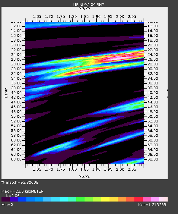
| Estimated Moho Depth: |
23.0 km |
| Estimated Crust Vp/Vs: |
2.06 |
| Assumed Crust Vp: |
6.566 km/s |
| Estimated Crust Vs: |
3.187 km/s |
| Estimated Crust Poisson's Ratio: |
0.35 |
|
| Radial Match: |
93.30068 % |
| Radial Bump: |
400 |
| Transverse Match: |
90.18788 % |
| Transverse Bump: |
400 |
| SOD ConfigId: |
7422571 |
| Insert Time: |
2019-04-21 11:35:42.332 +0000 |
| GWidth: |
2.5 |
| Max Bumps: |
400 |
| Tol: |
0.001 |
|
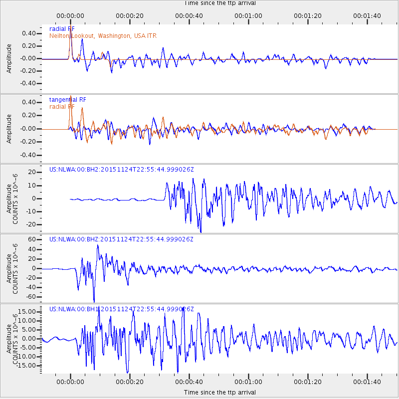
Signal To Noise
| Channel | StoN | STA | LTA |
| US:NLWA:00:BHZ:20151124T22:55:44.999026Z | 27.483906 | 1.5587397E-5 | 5.6714634E-7 |
| US:NLWA:00:BH1:20151124T22:55:44.999026Z | 4.2840867 | 3.3856738E-6 | 7.902907E-7 |
| US:NLWA:00:BH2:20151124T22:55:44.999026Z | 11.1542015 | 5.0410745E-6 | 4.5194403E-7 |
| Arrivals |
| Ps | 3.8 SECOND |
| PpPs | 10 SECOND |
| PsPs/PpSs | 14 SECOND |


