You are here: Home > Network List > UW - Pacific Northwest Regional Seismic Network Stations List
> Station HOOD Mt Hood Meadows, OR CREST BB SMO > Earthquake Result Viewer
HOOD Mt Hood Meadows, OR CREST BB SMO - Earthquake Result Viewer

| Earthquake location: |
Peru-Brazil Border Region |
| Earthquake latitude/longitude: |
-10.6/-71.0 |
| Earthquake time(UTC): |
2015/11/24 (328) 22:45:38 GMT |
| Earthquake Depth: |
602 km |
| Earthquake Magnitude: |
7.5 MWW, 6.9 MI |
| Earthquake Catalog/Contributor: |
NEIC PDE/NEIC COMCAT |
|
| Network: |
UW Pacific Northwest Regional Seismic Network |
| Station: |
HOOD Mt Hood Meadows, OR CREST BB SMO |
| Lat/Lon: |
45.32 N/121.65 W |
| Elevation: |
1520 m |
|
| Distance: |
71.9 deg |
| Az: |
324.959 deg |
| Baz: |
126.854 deg |
| Ray Param: |
0.051944874 |
| Estimated Moho Depth: |
37.75 km |
| Estimated Crust Vp/Vs: |
1.74 |
| Assumed Crust Vp: |
6.597 km/s |
| Estimated Crust Vs: |
3.797 km/s |
| Estimated Crust Poisson's Ratio: |
0.25 |
|
| Radial Match: |
94.60172 % |
| Radial Bump: |
400 |
| Transverse Match: |
93.39699 % |
| Transverse Bump: |
400 |
| SOD ConfigId: |
7422571 |
| Insert Time: |
2019-04-21 11:35:57.361 +0000 |
| GWidth: |
2.5 |
| Max Bumps: |
400 |
| Tol: |
0.001 |
|
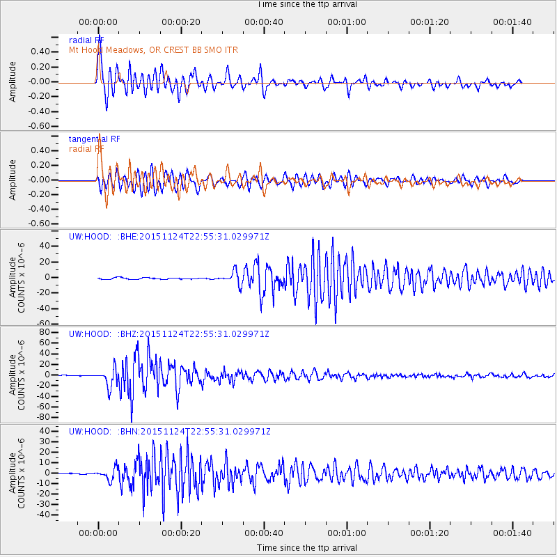
Signal To Noise
| Channel | StoN | STA | LTA |
| UW:HOOD: :BHZ:20151124T22:55:31.029971Z | 25.124758 | 1.7071487E-5 | 6.794687E-7 |
| UW:HOOD: :BHN:20151124T22:55:31.029971Z | 9.146497 | 5.7097773E-6 | 6.2425835E-7 |
| UW:HOOD: :BHE:20151124T22:55:31.029971Z | 8.164766 | 8.255944E-6 | 1.0111671E-6 |
| Arrivals |
| Ps | 4.4 SECOND |
| PpPs | 15 SECOND |
| PsPs/PpSs | 19 SECOND |


