You are here: Home > Network List > XD14 - Illuminating the architecture of the greater Mount St. Helens magmatic systems f Stations List
> Station MB07 "Mount St Helens, WA" > Earthquake Result Viewer
MB07 "Mount St Helens, WA" - Earthquake Result Viewer
| Earthquake location: |
Peru-Brazil Border Region |
| Earthquake latitude/longitude: |
-10.6/-71.0 |
| Earthquake time(UTC): |
2015/11/24 (328) 22:45:38 GMT |
| Earthquake Depth: |
602 km |
| Earthquake Magnitude: |
7.5 MWW, 6.9 MI |
| Earthquake Catalog/Contributor: |
NEIC PDE/NEIC COMCAT |
|
| Network: |
XD Illuminating the architecture of the greater Mount St. Helens magmatic systems f |
| Station: |
MB07 "Mount St Helens, WA" |
| Lat/Lon: |
46.62 N/122.04 W |
| Elevation: |
878 m |
|
| Distance: |
72.9 deg |
| Az: |
325.881 deg |
| Baz: |
126.854 deg |
| Ray Param: |
0.0513113 |
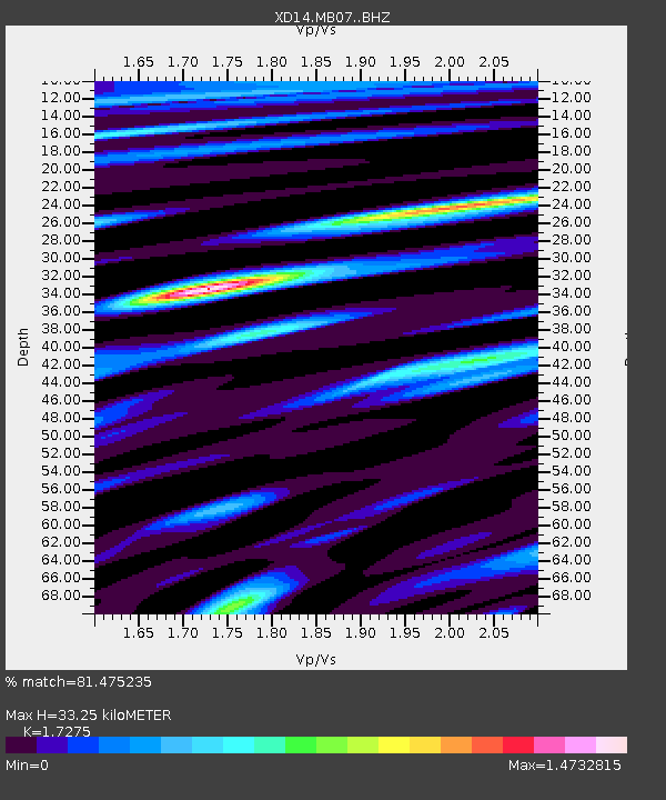
| Estimated Moho Depth: |
33.25 km |
| Estimated Crust Vp/Vs: |
1.73 |
| Assumed Crust Vp: |
6.566 km/s |
| Estimated Crust Vs: |
3.801 km/s |
| Estimated Crust Poisson's Ratio: |
0.25 |
|
| Radial Match: |
81.475235 % |
| Radial Bump: |
373 |
| Transverse Match: |
78.51909 % |
| Transverse Bump: |
400 |
| SOD ConfigId: |
7422571 |
| Insert Time: |
2019-04-21 11:36:41.883 +0000 |
| GWidth: |
2.5 |
| Max Bumps: |
400 |
| Tol: |
0.001 |
|

Signal To Noise
| Channel | StoN | STA | LTA |
| XD:MB07: :BHZ:20151124T22:55:36.744998Z | 17.605646 | 1.2231378E-5 | 6.9474174E-7 |
| XD:MB07: :BHN:20151124T22:55:36.744998Z | 2.7655313 | 2.073776E-6 | 7.498653E-7 |
| XD:MB07: :BHE:20151124T22:55:36.744998Z | 3.652558 | 2.4395363E-6 | 6.6789806E-7 |
| Arrivals |
| Ps | 3.8 SECOND |
| PpPs | 13 SECOND |
| PsPs/PpSs | 17 SECOND |


