You are here: Home > Network List > XD14 - Illuminating the architecture of the greater Mount St. Helens magmatic systems f Stations List
> Station MI09 "Mount St Helens, WA" > Earthquake Result Viewer
MI09 "Mount St Helens, WA" - Earthquake Result Viewer
| Earthquake location: |
Peru-Brazil Border Region |
| Earthquake latitude/longitude: |
-10.6/-71.0 |
| Earthquake time(UTC): |
2015/11/24 (328) 22:45:38 GMT |
| Earthquake Depth: |
602 km |
| Earthquake Magnitude: |
7.5 MWW, 6.9 MI |
| Earthquake Catalog/Contributor: |
NEIC PDE/NEIC COMCAT |
|
| Network: |
XD Illuminating the architecture of the greater Mount St. Helens magmatic systems f |
| Station: |
MI09 "Mount St Helens, WA" |
| Lat/Lon: |
46.23 N/121.83 W |
| Elevation: |
1003 m |
|
| Distance: |
72.6 deg |
| Az: |
325.641 deg |
| Baz: |
126.933 deg |
| Ray Param: |
0.051537227 |
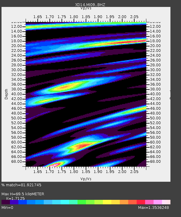
| Estimated Moho Depth: |
69.5 km |
| Estimated Crust Vp/Vs: |
1.71 |
| Assumed Crust Vp: |
6.597 km/s |
| Estimated Crust Vs: |
3.853 km/s |
| Estimated Crust Poisson's Ratio: |
0.24 |
|
| Radial Match: |
81.921745 % |
| Radial Bump: |
400 |
| Transverse Match: |
76.513885 % |
| Transverse Bump: |
400 |
| SOD ConfigId: |
7422571 |
| Insert Time: |
2019-04-21 11:37:08.191 +0000 |
| GWidth: |
2.5 |
| Max Bumps: |
400 |
| Tol: |
0.001 |
|

Signal To Noise
| Channel | StoN | STA | LTA |
| XD:MI09: :BHZ:20151124T22:55:34.750002Z | 24.600533 | 1.2565655E-5 | 5.1078797E-7 |
| XD:MI09: :BHN:20151124T22:55:34.750002Z | 7.915332 | 3.815345E-6 | 4.820196E-7 |
| XD:MI09: :BHE:20151124T22:55:34.750002Z | 6.0914865 | 2.9618016E-6 | 4.8621985E-7 |
| Arrivals |
| Ps | 7.8 SECOND |
| PpPs | 28 SECOND |
| PsPs/PpSs | 35 SECOND |


