You are here: Home > Network List > XD14 - Illuminating the architecture of the greater Mount St. Helens magmatic systems f Stations List
> Station ML03 "Mount St Helens, WA" > Earthquake Result Viewer
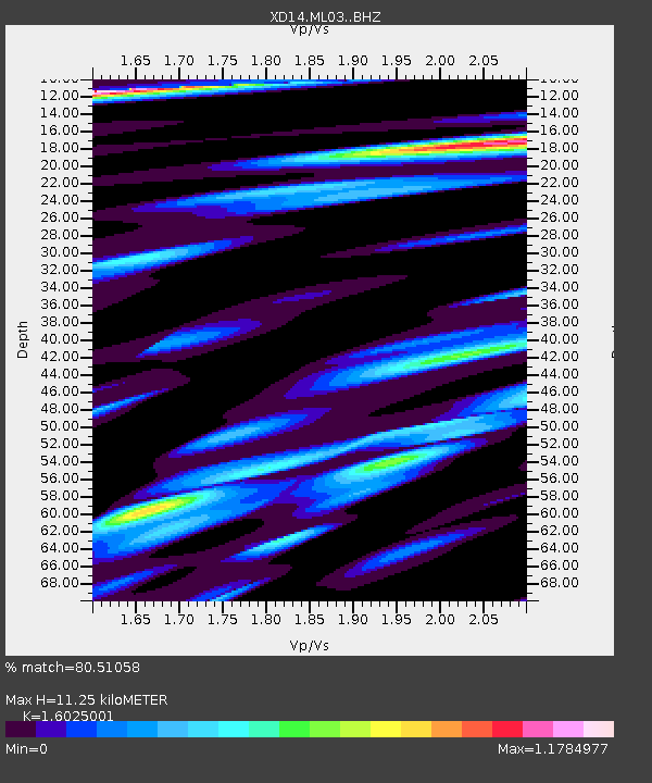
ML03 "Mount St Helens, WA" - Earthquake Result Viewer
| Earthquake location: |
Peru-Brazil Border Region |
| Earthquake latitude/longitude: |
-10.6/-71.0 |
| Earthquake time(UTC): |
2015/11/24 (328) 22:45:38 GMT |
| Earthquake Depth: |
602 km |
| Earthquake Magnitude: |
7.5 MWW, 6.9 MI |
| Earthquake Catalog/Contributor: |
NEIC PDE/NEIC COMCAT |
|
| Network: |
XD Illuminating the architecture of the greater Mount St. Helens magmatic systems f |
| Station: |
ML03 "Mount St Helens, WA" |
| Lat/Lon: |
46.06 N/122.52 W |
| Elevation: |
356 m |
|
| Distance: |
72.9 deg |
| Az: |
325.205 deg |
| Baz: |
126.313 deg |
| Ray Param: |
0.051357012 |
| Estimated Moho Depth: |
11.25 km |
| Estimated Crust Vp/Vs: |
1.60 |
| Assumed Crust Vp: |
6.566 km/s |
| Estimated Crust Vs: |
4.097 km/s |
| Estimated Crust Poisson's Ratio: |
0.18 |
|
| Radial Match: |
80.51058 % |
| Radial Bump: |
400 |
| Transverse Match: |
75.83373 % |
| Transverse Bump: |
400 |
| SOD ConfigId: |
7422571 |
| Insert Time: |
2019-04-21 11:37:18.691 +0000 |
| GWidth: |
2.5 |
| Max Bumps: |
400 |
| Tol: |
0.001 |
|

Signal To Noise
| Channel | StoN | STA | LTA |
| XD:ML03: :BHZ:20151124T22:55:36.344973Z | 21.531958 | 1.3123259E-5 | 6.0947826E-7 |
| XD:ML03: :BHN:20151124T22:55:36.344973Z | 2.7467577 | 1.5436225E-6 | 5.6197985E-7 |
| XD:ML03: :BHE:20151124T22:55:36.344973Z | 8.154923 | 4.616533E-6 | 5.661038E-7 |
| Arrivals |
| Ps | 1.1 SECOND |
| PpPs | 4.3 SECOND |
| PsPs/PpSs | 5.4 SECOND |


