You are here: Home > Network List > XD14 - Illuminating the architecture of the greater Mount St. Helens magmatic systems f Stations List
> Station MM08 "Mount St Helens, WA" > Earthquake Result Viewer
MM08 "Mount St Helens, WA" - Earthquake Result Viewer
| Earthquake location: |
Peru-Brazil Border Region |
| Earthquake latitude/longitude: |
-10.6/-71.0 |
| Earthquake time(UTC): |
2015/11/24 (328) 22:45:38 GMT |
| Earthquake Depth: |
602 km |
| Earthquake Magnitude: |
7.5 MWW, 6.9 MI |
| Earthquake Catalog/Contributor: |
NEIC PDE/NEIC COMCAT |
|
| Network: |
XD Illuminating the architecture of the greater Mount St. Helens magmatic systems f |
| Station: |
MM08 "Mount St Helens, WA" |
| Lat/Lon: |
46.03 N/121.98 W |
| Elevation: |
1019 m |
|
| Distance: |
72.5 deg |
| Az: |
325.411 deg |
| Baz: |
126.756 deg |
| Ray Param: |
0.051559478 |
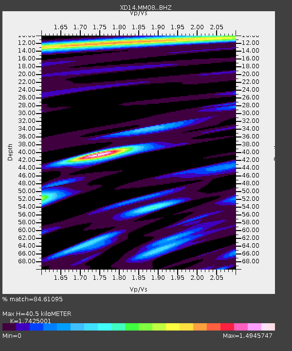
| Estimated Moho Depth: |
40.5 km |
| Estimated Crust Vp/Vs: |
1.74 |
| Assumed Crust Vp: |
6.597 km/s |
| Estimated Crust Vs: |
3.786 km/s |
| Estimated Crust Poisson's Ratio: |
0.25 |
|
| Radial Match: |
84.61095 % |
| Radial Bump: |
400 |
| Transverse Match: |
77.24504 % |
| Transverse Bump: |
400 |
| SOD ConfigId: |
7422571 |
| Insert Time: |
2019-04-21 11:37:23.982 +0000 |
| GWidth: |
2.5 |
| Max Bumps: |
400 |
| Tol: |
0.001 |
|

Signal To Noise
| Channel | StoN | STA | LTA |
| XD:MM08: :BHZ:20151124T22:55:34.544985Z | 30.375034 | 1.578668E-5 | 5.1972546E-7 |
| XD:MM08: :BHN:20151124T22:55:34.544985Z | 4.005906 | 3.6340332E-6 | 9.0716884E-7 |
| XD:MM08: :BHE:20151124T22:55:34.544985Z | 4.563664 | 4.533094E-6 | 9.933015E-7 |
| Arrivals |
| Ps | 4.7 SECOND |
| PpPs | 16 SECOND |
| PsPs/PpSs | 21 SECOND |


