You are here: Home > Network List > YT07 - POLENET Stations List
> Station FISH FISH > Earthquake Result Viewer
FISH FISH - Earthquake Result Viewer
| Earthquake location: |
Peru-Brazil Border Region |
| Earthquake latitude/longitude: |
-10.6/-71.0 |
| Earthquake time(UTC): |
2015/11/24 (328) 22:45:38 GMT |
| Earthquake Depth: |
602 km |
| Earthquake Magnitude: |
7.5 MWW, 6.9 MI |
| Earthquake Catalog/Contributor: |
NEIC PDE/NEIC COMCAT |
|
| Network: |
YT POLENET |
| Station: |
FISH FISH |
| Lat/Lon: |
78.93 S/162.57 E |
| Elevation: |
273 m |
|
| Distance: |
86.2 deg |
| Az: |
188.962 deg |
| Baz: |
127.589 deg |
| Ray Param: |
0.0424606 |
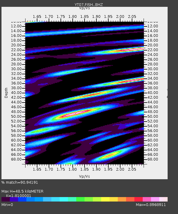
| Estimated Moho Depth: |
48.5 km |
| Estimated Crust Vp/Vs: |
1.81 |
| Assumed Crust Vp: |
6.43 km/s |
| Estimated Crust Vs: |
3.552 km/s |
| Estimated Crust Poisson's Ratio: |
0.28 |
|
| Radial Match: |
90.94191 % |
| Radial Bump: |
400 |
| Transverse Match: |
89.00518 % |
| Transverse Bump: |
400 |
| SOD ConfigId: |
7422571 |
| Insert Time: |
2019-04-21 11:38:12.081 +0000 |
| GWidth: |
2.5 |
| Max Bumps: |
400 |
| Tol: |
0.001 |
|

Signal To Noise
| Channel | StoN | STA | LTA |
| YT:FISH: :BHZ:20151124T22:56:46.273989Z | 101.152245 | 1.5498492E-5 | 1.5321945E-7 |
| YT:FISH: :BHN:20151124T22:56:46.273989Z | 30.018751 | 3.7377245E-6 | 1.2451298E-7 |
| YT:FISH: :BHE:20151124T22:56:46.273989Z | 21.655653 | 3.8841426E-6 | 1.7935928E-7 |
| Arrivals |
| Ps | 6.2 SECOND |
| PpPs | 21 SECOND |
| PsPs/PpSs | 27 SECOND |


