You are here: Home > Network List > ZW13 - Locating North Texas Earthquakes Stations List
> Station AZWP Azle B3 > Earthquake Result Viewer
AZWP Azle B3 - Earthquake Result Viewer
| Earthquake location: |
Peru-Brazil Border Region |
| Earthquake latitude/longitude: |
-10.6/-71.0 |
| Earthquake time(UTC): |
2015/11/24 (328) 22:45:38 GMT |
| Earthquake Depth: |
602 km |
| Earthquake Magnitude: |
7.5 MWW, 6.9 MI |
| Earthquake Catalog/Contributor: |
NEIC PDE/NEIC COMCAT |
|
| Network: |
ZW Locating North Texas Earthquakes |
| Station: |
AZWP Azle B3 |
| Lat/Lon: |
32.78 N/97.66 W |
| Elevation: |
381 m |
|
| Distance: |
50.1 deg |
| Az: |
330.436 deg |
| Baz: |
144.84 deg |
| Ray Param: |
0.065460406 |
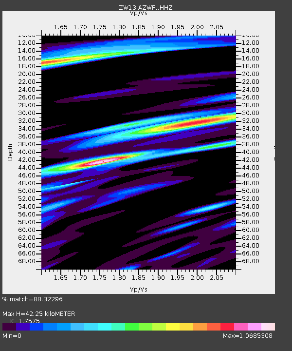
| Estimated Moho Depth: |
42.25 km |
| Estimated Crust Vp/Vs: |
1.76 |
| Assumed Crust Vp: |
6.38 km/s |
| Estimated Crust Vs: |
3.63 km/s |
| Estimated Crust Poisson's Ratio: |
0.26 |
|
| Radial Match: |
88.32296 % |
| Radial Bump: |
400 |
| Transverse Match: |
69.531685 % |
| Transverse Bump: |
400 |
| SOD ConfigId: |
7422571 |
| Insert Time: |
2019-04-21 11:38:41.728 +0000 |
| GWidth: |
2.5 |
| Max Bumps: |
400 |
| Tol: |
0.001 |
|

Signal To Noise
| Channel | StoN | STA | LTA |
| ZW:AZWP: :HHZ:20151124T22:53:08.760012Z | 58.547764 | 1.6719456E-5 | 2.8556948E-7 |
| ZW:AZWP: :HHN:20151124T22:53:08.760012Z | 9.509003 | 6.9018606E-6 | 7.258238E-7 |
| ZW:AZWP: :HHE:20151124T22:53:08.760012Z | 5.9832106 | 3.618097E-6 | 6.047083E-7 |
| Arrivals |
| Ps | 5.3 SECOND |
| PpPs | 17 SECOND |
| PsPs/PpSs | 23 SECOND |


