You are here: Home > Network List > CI - Caltech Regional Seismic Network Stations List
> Station PAS Pasadena, Pasadena, CA, USA > Earthquake Result Viewer
PAS Pasadena, Pasadena, CA, USA - Earthquake Result Viewer

| Earthquake location: |
Kodiak Island Region, Alaska |
| Earthquake latitude/longitude: |
57.4/-154.5 |
| Earthquake time(UTC): |
1999/12/06 (340) 23:12:33 GMT |
| Earthquake Depth: |
66 km |
| Earthquake Magnitude: |
6.8 MB, 7.0 MW, 7.0 ML |
| Earthquake Catalog/Contributor: |
WHDF/NEIC |
|
| Network: |
CI Caltech Regional Seismic Network |
| Station: |
PAS Pasadena, Pasadena, CA, USA |
| Lat/Lon: |
34.15 N/118.17 W |
| Elevation: |
314 m |
|
| Distance: |
33.7 deg |
| Az: |
117.854 deg |
| Baz: |
324.766 deg |
| Ray Param: |
0.07790131 |
| Estimated Moho Depth: |
35.75 km |
| Estimated Crust Vp/Vs: |
1.60 |
| Assumed Crust Vp: |
6.1 km/s |
| Estimated Crust Vs: |
3.812 km/s |
| Estimated Crust Poisson's Ratio: |
0.18 |
|
| Radial Match: |
91.40298 % |
| Radial Bump: |
315 |
| Transverse Match: |
85.096466 % |
| Transverse Bump: |
400 |
| SOD ConfigId: |
3787 |
| Insert Time: |
2010-02-25 23:58:19.986 +0000 |
| GWidth: |
2.5 |
| Max Bumps: |
400 |
| Tol: |
0.001 |
|
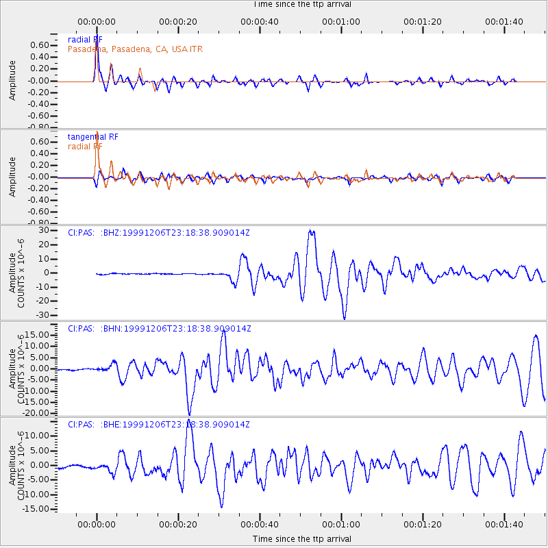
Signal To Noise
| Channel | StoN | STA | LTA |
| CI:PAS: :BHN:19991206T23:18:38.909014Z | 8.839173 | 1.7534081E-6 | 1.9836789E-7 |
| CI:PAS: :BHE:19991206T23:18:38.909014Z | 3.7051785 | 1.5134809E-6 | 4.0847718E-7 |
| CI:PAS: :BHZ:19991206T23:18:38.909014Z | 15.85626 | 3.9711726E-6 | 2.5044827E-7 |
| Arrivals |
| Ps | 3.8 SECOND |
| PpPs | 14 SECOND |
| PsPs/PpSs | 18 SECOND |


