You are here: Home > Network List > CN - Canadian National Seismograph Network Stations List
> Station A16 Riviere Ouelle, QC, CA > Earthquake Result Viewer
A16 Riviere Ouelle, QC, CA - Earthquake Result Viewer
| Earthquake location: |
Peru-Brazil Border Region |
| Earthquake latitude/longitude: |
-10.1/-71.1 |
| Earthquake time(UTC): |
2015/11/24 (328) 22:50:53 GMT |
| Earthquake Depth: |
595 km |
| Earthquake Magnitude: |
5.9 MB |
| Earthquake Catalog/Contributor: |
NEIC PDE/NEIC COMCAT |
|
| Network: |
CN Canadian National Seismograph Network |
| Station: |
A16 Riviere Ouelle, QC, CA |
| Lat/Lon: |
47.47 N/70.01 W |
| Elevation: |
13 m |
|
| Distance: |
57.3 deg |
| Az: |
0.859 deg |
| Baz: |
181.247 deg |
| Ray Param: |
0.06107249 |
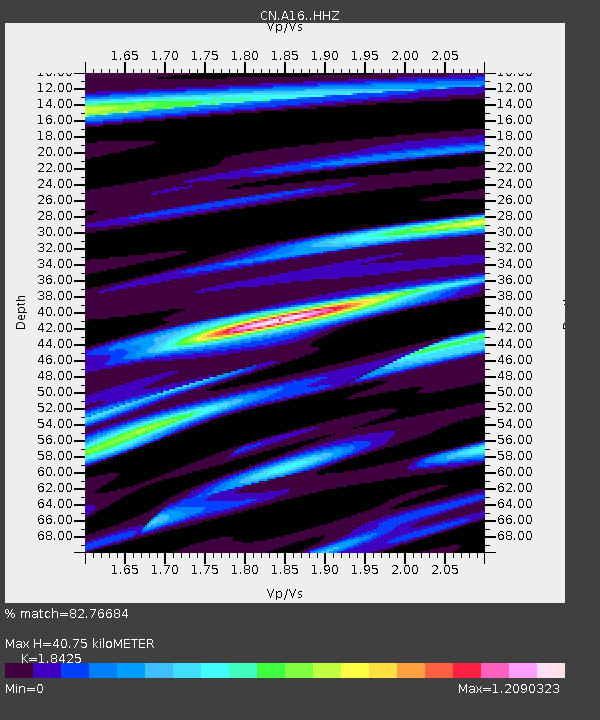
| Estimated Moho Depth: |
40.75 km |
| Estimated Crust Vp/Vs: |
1.84 |
| Assumed Crust Vp: |
6.61 km/s |
| Estimated Crust Vs: |
3.588 km/s |
| Estimated Crust Poisson's Ratio: |
0.29 |
|
| Radial Match: |
82.76684 % |
| Radial Bump: |
359 |
| Transverse Match: |
66.391685 % |
| Transverse Bump: |
400 |
| SOD ConfigId: |
7422571 |
| Insert Time: |
2019-04-21 11:43:17.816 +0000 |
| GWidth: |
2.5 |
| Max Bumps: |
400 |
| Tol: |
0.001 |
|

Signal To Noise
| Channel | StoN | STA | LTA |
| CN:A16: :HHZ:20151124T22:59:13.859985Z | 16.847082 | 3.2839365E-5 | 1.949261E-6 |
| CN:A16: :HHN:20151124T22:59:13.859985Z | 5.885261 | 1.5017834E-5 | 2.5517702E-6 |
| CN:A16: :HHE:20151124T22:59:13.859985Z | 1.8179111 | 2.9174091E-6 | 1.604814E-6 |
| Arrivals |
| Ps | 5.4 SECOND |
| PpPs | 17 SECOND |
| PsPs/PpSs | 22 SECOND |


